25. Luxeuil loop Amage region

Bourgogne-Franche-Comté
25. Luxeuil loop Amage region
Easy
3h
10,2km
+313m
-314m
Embed this item to access it offline
The route mainly runs through forest on both the outward and return journeys. The first third follows the marked route of a stage of the Via Columbani between Luxeuil and Annegray, where Saint Columbanus arrived from Ireland in 590.
Identical to the photo shown, these markers feature a QR code that allows you to display the guidebook for this stage on your phone or tablet and follow the route on a map using geolocation.
Identical to the photo shown, these markers feature a QR code that allows you to display the guidebook for this stage on your phone or tablet and follow the route on a map using geolocation.
3 points of interest
 Historical
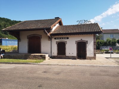
Old Tacot railway station
The Haute-Saône local railways are a former network of secondary departmental railways with metre gauge tracks, operated by the Compagnie Générale des Chemins de Fer Vicinaux (CFV), which in 1888 took over from the Compagnie du Chemin de Fer de Gray à Gy, concessionaire of the line of the same name since 1871, but then in bankruptcy. The train running on this network is locally and colloquially nicknamed ‘le tacot’ (the old banger).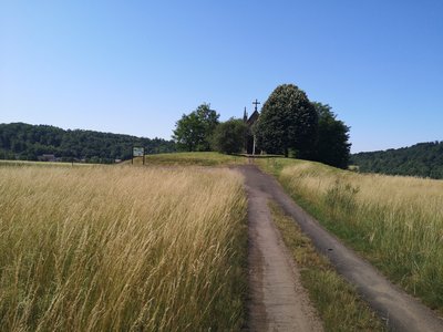 Historical
Saint Roch Chapel
The Saint Roch Chapel was built in 1636 on the very spot where the victims of the plague were buried. A burial mound marks the site of their graves. It was a simple wooden chapel that was gradually abandoned. When cholera began to rage in 1853, the inhabitants and those of the neighbouring villages vowed to rebuild it. The plague spared the valley, and the current chapel was built.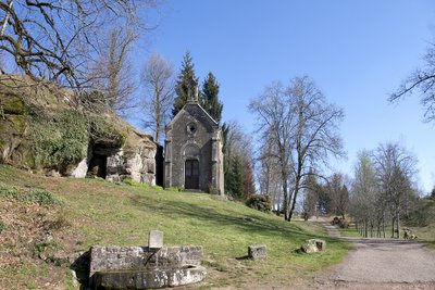
Vue panoramique de la grotte, de la chapelle et du chemin d’arrivée sur le site - Amis de saint Colomban St ColumbanThe Grotto of Saint Colomban at Sainte-Marie en Chanois
In der Tradition des keltischen Mönchtums zogen sich die Mönche vor den großen Festen des Christentums aus der Gemeinschaft zurück, um zu beten, zu fasten und zu meditieren.
Der heilige Kolumbaner pflegte sich in eine Höhle zurückzuziehen, die eine Stunde Fußmarsch von Annegray entfernt liegt. Von dort aus konnte er seine Brüder in Annegray sehen. Die Vita Columbani erzählt, dass eines Tages ein Bär seine Höhle besetzte, er befahl ihm, diesen Ort zu verlassen, was das Tier tat, ohne zu protestieren, diese Episode wird in vielen Vita von Mönchen Jünger von Colomban wiederholt werden.
Nutzen Sie die Stille und die Schönheit der Landschaft, um eine Pause einzulegen.
Diese Website wurde von Dr. Gilles Cugnier, dem Präsidenten der Vereinigung der Freunde von St. Kolumbien, vor dem Vergessen gerettet und verschönert.
Description
The route starts in front of the old railway station:
- Take Rue du Tacot heading south-east and turn right at the first street to join the D 6. Turn right then take Chemin de la Sablière on the left. When you reach the D139, follow the Via-Columbani signs (old monks' path).
- Stop at the Saint-Roch chapel before arriving at Sainte-Marie-en-Chanois.
- Cross the D 6 and continue straight on Rue Saint Colomban. After 500 m, turn right onto Rue La Collonge (leaving the signposts).
- Pass No. 26 and turn left onto the path leading up into the forest. Rejoin the signposts and continue to the cave and Saint-Colomban Chapel.
- After the chapel (leaving the signposts until the end of the hike), take a tarmac road and follow it for 800 m. Pass the ‘Pas de Deux’ and then turn right to reach the hamlet of ‘Belle Fleur’.
- Turn left onto the tree-lined path for 500 m and turn left again onto a narrow path lined with broom.
- At the first intersection (500 m), turn left and follow the path downhill.
- After 600 m, turn left onto a forest road and follow it uphill to the hunters' hut, then take the path on the right.
- Walk 500 m and turn completely left, continuing for 1.3 km until you reach the tarmac road ‘Chemin des Champs de la Pierre’. Turn left and join Rue du Tacot. The station is on your right.
- Departure : 70280 Amage, former Tacot railway station, station square
- Arrival : 70280 Amage, former Tacot railway station, station square
- Towns crossed : Bourgogne-Franche-Comté
Altimetric profile
Access and parking
The starting point is the old Tacot railway station, Place de la Gare, accessible via the D 6.
Parking :
Amage 70280, former Tacot railway station.
Report a problem or an error
If you have found an error on this page or if you have noticed any problems during your hike, please report them to us here: