29. Hohenems-Rhine-Hohenems region
The first part is on flat ground and therefore relatively level, while the second part is more hilly and wooded.
4 points of interest
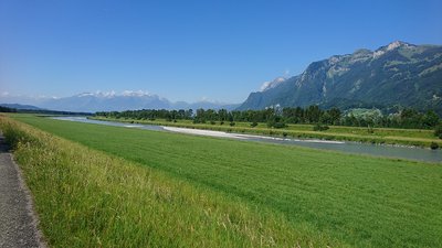 Panoramic
The Old and New Rhine
The Old Rhine used to form a sharp bend here, which regularly caused severe flooding. That is why the river was straightened in 1923 by cutting through the bend. Today, the area is home to a beautiful nature reserve. The border between Switzerland and Austria follows the course of the Old Rhine.
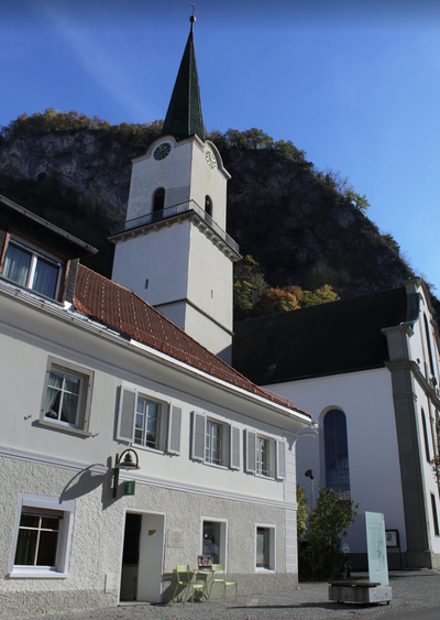
 Historical
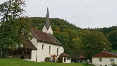
St Arbogast Sanctuary
The sanctuary was built in 1473 and extended in 1710. The high altar, dating from 1655 and featuring a Renaissance-style composition, is adorned with an altarpiece depicting the Coronation of Mary, created around 1660, and includes statues of Saint James on the left, Saint Roch on the right, and Saint Arbogast in the upper panel.
 Panoramic
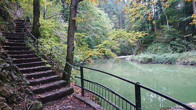
Örfla Gorge
The Örfla Gorge is a gorge along the Emmebach. The gorge forms part of the ‘Hohe Kugel – Hoher Freschen – Mellental’ nature reserve and is listed in the Vorarlberg biotope inventory.
 Historical
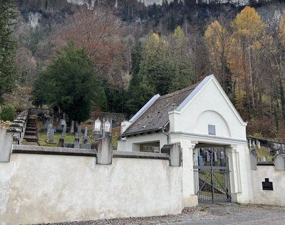
Jewish cemetery
The cemetery is as old as the Jewish community in the town, which dates back to 1617. It contains around 500 graves, 370 of which are very well preserved.
Description
The route starts west of the station, which means crossing the railway tracks via underground passages to reach Herrenriedstrasse and turning left until you reach the next roundabout:
- Turn right onto the main street, Nibelungenstrasse. At the end, turn left onto Lustenauerstrasse and follow it for 40 metres, then take the second street on the right marked by a bridge. Follow Barnabas Fink Strasse and then Weidenstrasse until you reach a factory with ponds.
- Turn right onto the north-west facing track, which then heads west along the Koblacher Kanal. After passing under the motorway, cross the canal and follow Rheinau road, which runs alongside car parks and sports fields. At the end of these fields, turn right (Erich Billig monument) to reach the Old Rhine, passing to the right of a basin. After 300 metres westwards, at a strip of land that cuts across the Old Rhine, turn left, pass by the Galerie im Kies and follow the Old Rhine westwards to its end, where the path makes a sharp turn to the east.
- At the signpost, follow Oberer Dammweg south-west, which joins Sandgrube in Mäder after 450 metres. Continue along the road between the Rhine and an industrial estate before crossing the L58 road. The path then passes between a railway line on the right and sports fields on the left. After the tennis courts, turn left and then right along the Kablacher Kanal. After 400 m, cross the canal and follow it on the other bank to the next bridge.
- Turn left and continue on Gässele for 300 m until you reach a fork in the road. Turn right onto Kutzenau street. After 100 metres, cross Reichshofstrasse and take Torkelweg. Go around the hill to the north, turning right at the Pocksberg bus park. Turn into the second street on the left, Engerle, and follow the bottom of the cliffs. At the entrance to an industrial estate, turn left onto the cycle path to go around the business park. After 500 metres, take the first road on the right next to a large building and head south towards the hills. Climb the path and go over a small pass before descending and joining a main road after 300 metres.
- Follow the cycle path on the left along this road for 400 metres, passing under the motorway to reach a roundabout. Continue eastwards on Montlinger Strasse, passing under a railway line and continuing to the traffic lights at the junction with Doktor Alfons Heinzle Strasse. Turn right onto this street and follow it for 400 metres to cross the first stream, Moosgraben. At the second stream, Kaltbrunnenbach (signposted), turn left and follow the stream. The path leaves the built-up area and climbs into the forest along the stream, which it crosses several times. When you reach Sunnahof, turn right onto Montfortstrasse, which joins a larger road to the east. Turn left towards the north, then right after the hamlet of Sankt Arbogast at a car park. Follow this road uphill with two hairpin bends. After the pass, continue east for 400 metres to reach a crossroads with Örflaweg, which marks the arrival on Kolumbansweg, which continues south.
- Turn left (signpost) and continue north through the valley along the Rheintalweg Vorarlberg, which follows the Emmebach stream. At the reservoir, turn left towards the west, pass a chapel and continue along the stream. After the swimming pool, turn right at the edge of the car park and climb northwards to a larger road (Bulitta). Turn left and then immediately right onto Am Hof, heading north. Continue along Am Hof, which descends to the foot of the hill. At the end, turn right onto Römerweg at the edge of the forest before entering the town. At the signpost, turn left and take the next path on the right to join the main road Im Buch. Turn right at the roundabout and, at the car park, follow a small road on the right, then a path at the foot of the cliffs that leads to the main road Kaiser Franz Joseph Strasse at Schwefef.
- After 100 metres along this road, turn right onto Gottfried Keller Strasse and continue at the foot of the hill. When the road curves to the left, continue along the path in the same direction until the end (signpost). Turn left onto Schützenstrasse. At the end, turn right onto Kaiser Josef Strasse and then, after 150 metres, right again onto Mozartstrasse. After the Hollbach stream, leave this street and turn right onto St Anton Strasse until it ends at Hochquellenstrasse. Turn left and then continue right onto Emsbachstrasse, which runs alongside the stream. Before the bridge, take the small street on the left to the restaurant. Turn right and then left to reach the main street, Kaiser Franz Josef Strasse. Cross it to reach Graf Maximilian Strasse, which leads to the station.
- Departure : A-6845 Hohenems (Austria), railway station
- Arrival : A-6845 Hohenems (Austria), railway station
Altimetric profile
Transport
In Götzis, you can take the bus or train back to Hohenems if you don’t want to walk the whole route or split it into two sections.
Access and parking
For those arriving by car, Hohenems railway station in Austria can be reached via the motorway that runs alongside the Rhine and then via the L46 road.
There are numerous car parks available next to the station.
Report a problem or an error
If you have found an error on this page or if you have noticed any problems during your hike, please report them to us here: