Reims to Trépail
Grand Est
5. Reims to Trépail
Medium
6h30
25,1km
+415m
-330m
Step
Embed this item to access it offline
After following the canal from the Aisne to the Marne you will enter the Champagne vineyards with their landscapes and the Moulin de Verzelay in your sights. The mill cannot be visited but the view over the hilly vineyard deserves a break. You walk between the vineyards and the forest of the Montagne de Reims to meet an old monastery, raised by monks from the monastery of Luxeuil in the 7th century. A chapel recalls its presence.
11 points of interest
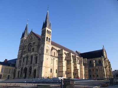
Basilique Saint-Rémi de Reims - Amis saint Colomban HistoricalSaint-Rémi Basilica in Reims.
This church symbolizes the conversion of the Franks to Catholicism, through the baptism of Clovis by Saint-Rémi, bishop of Rheims between 495 and 500. Although the baptism was celebrated in the cathedral of Rheims, the relics of Saint-Remi were buried in a church that would become the eponymous basilica. In the 7th century a Benedictine religious community settled in a monastery near the relics of the Saint. In the 9th century a new Carolingian basilica was built, replaced a century later by a building in French-speaking Switzerland. The congregation of Saint-Maur carries out important works in a flamboyant 16th century style.
More information: Wikipedia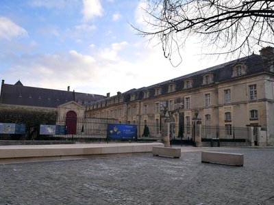
Plais du Tau accès depuis la cathédrale - Amis saint Colomban HistoricalPalais du Tau à Reims
In the 5th century Bishop Nicaise built a church dedicated to Our Lady and settled nearby on the remains of a Gallo-Roman villa. The building was enlarged over the centuries and in the 12th century it took the shape of a T (Tau in Greek).
Residence of all the kings who came to receive the Holy Chrism at the time of their coronation.
The 1905 law on the separation of Church and State put an end to the occupation of the palace by the bishop; the building is classified as a historical monument, and it was not until 1972 that a cathedral museum was installed.
More info: Wikipedia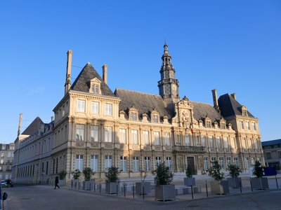
Hôtel de ville de Reims - Amis saint Colomban HistoricalReims City Hall
Until 1627, the aldermen of Rheims had no place to meet. Thanks to the repayment of a debt contracted by the Duke of Guise (Cardinal of Lorraine in 1550 then Archbishop of Rheims in 1538) during the Wars of Religion (1562-1598), the building of a Town Hall was decided. The Reims architect Jean Bonhomme built the pavilion on the left and then the central pavilion, but the building site had to stop for lack of money. In the 19th century, the architects Narcisse and Ernest Brunette completed the building, which housed several activities until the Great War: museum, library, court...
On May 3, 1917, the Town Hall was set on fire during the bombings. Only the façades remain and the architects Roger-Henri Expert and Paul Bouchette are in charge of the reconstruction in the 1920s.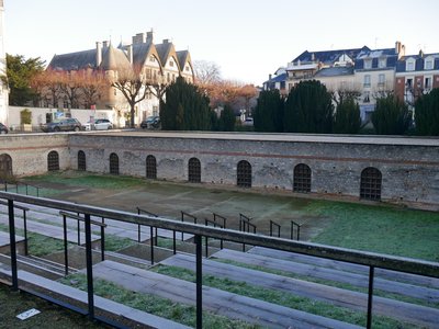
Vue du Cryptoportique de Reims - Amis saint Colomban HistoricalLe cryptoportique de Reims
Probably built between the 1st and 2nd centuries, the cryptoportico is a semi-buried part of the ancient forum. A political, religious, economic and social crossroads of the ancient city, it is surmounted by porticoes opening onto the adjacent streets.
In 1920 archaeological excavations discovered this witness of the ancient period.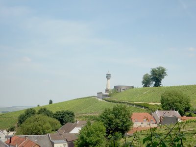
Musée du Phare de Verzenay - Amis saint Colomban TouristThe Lighthouse of Verzenay
Like a lighthouse on the Brittany coast, it signals its presence for advertising purposes from the end of the 19th century. Come and discover this original story of Joseph Goulet, son of a food trade entrepreneur who set up branches in the Paris region until the beginning of the First World War.
Goulet's name was inscribed on the entire height of the lighthouse. This company, which had been converted into a developing food trade centre between the two wars in the 20th century, disappeared in the 1970s. The site was abandoned and then restored to become a Champagne museum and offers you a trip into the bubbles of champagne.
More info at: maisons-champagne.com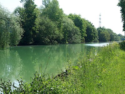
Paysage des bords du canal l’Aisne à la Marne - Amis saint Colomban PanoramicAisne to Marne Canal
In 1840 the French state decided to link the Marne-Rhine canal to all the navigable canals and rivers of northern France and to connect the ports of Nord, Pas-de-Calais, Le Havre and Rouen to Strasbourg. A considerable advantage, it allows transit goods to avoid Paris. At the time, the city had a large number of factories. 58 km long and comprising 24 locks, it is of the Freycinet gauge, and is fed by the Vesle at Sept-Sault, and a marl catchment at Condé. The first section Berry-au-Bac - Reims was inaugurated on 26 March 1848. In 1861, the southern part of the canal, linking Reims to Condé-sur-Marne, was completed. Reims will have two ports, the old port, created in 1848, in the centre of the city, and the Port Colbert dug in 1925. But the Darse, the basin mainly intended for berthing, will not be put into service until 1948. The traffic is experiencing at the end of the 19th century, and until 1980, a large attendance. Today, barges are rare. Pleasure boats are more and more numerous as well as the activities of the Régates Rémoises and the Cercle Nautique. In addition, the Coulée verte allows pedestrians and cyclists to access the banks of the canal and the Vesle.
Source: l'Union newspaper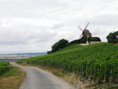
Le moulin de Verzenay devant la Via Columbani - Image : Amis de saint Colomban TouristThe Mill of Verzenay
Property of a Champagne company, the mill is reserved for receptions and cannot be visited. Its presence on a small hill, the Mont-Bœuf, does not escape the gaze of the walkers who pass by.
Built at the beginning of the 19th century to grind the cereals grown in the plain, it stopped working at the beginning of the 20th century. During the First World War it served as an observatory.
It is the last windmill attached to the Montagne de Reims, the restoration was carried out in 1946 for a Champagne company.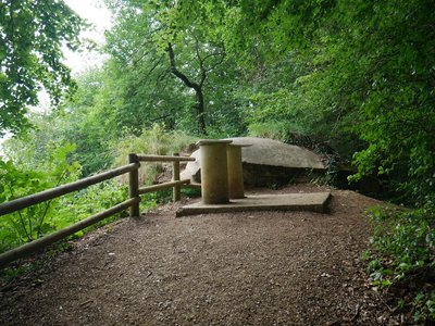
Le blockhaus d’observation et la plaque d’orientation - Image : Amis de saint Colomban HistoricalMount Sinai Observatory in the forest of Verzy
Mount Sinai Observatory is one of the most important places in the history of the First World War.
After the first battle of the Marne and the liberation of Reims by French troops on September 13, 1914, the edges of the plateau of the Mountain of Reims offer a strategic point of view to observe the movements of German troops.
This observatory completes a vast observation device of which the Verzenay mill was part.
Extract from the orientation plate on the site.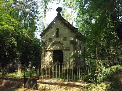
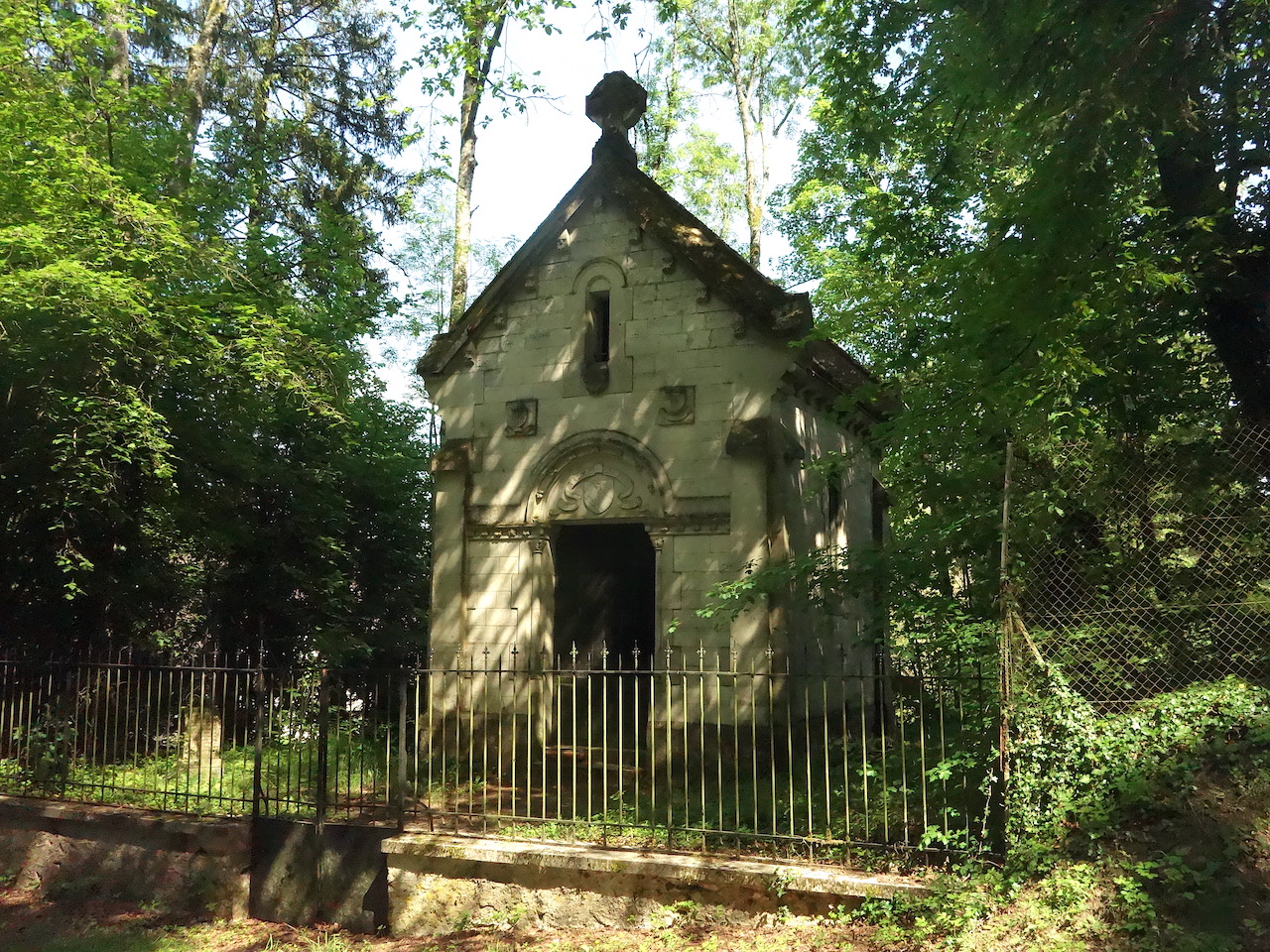
Chapelle Saint-Basle aux Faux de Verzy - Amis saint Colomban St ColumbanSaint-Basle de Verzy Abbey
According to Flodoard de Reims, historian and poet in the 10th century, a monastery was founded in Verzy in the time of Clovis (4th and early 5th century). It was located in the centre of the village of Verzy. The community would have followed the rules of the Desert Fathers. The monk Basle lived as a hermit in the forest of the mountain of Reims where he died around 620. His tomb was subject to miracles which prompted the bishop of Reims, Nivard, to build a monastery over his grave in his hermitage around 664, and he called upon the monks of Luxeuil to implement the mixed rule of the Good Fathers Benedict and Colomban.
In the 8th century, Charles Martel seized the property of the Saint-Basle monastery. In 926 the Hungarians settled in the monastery which was destroyed when the invaders left. In the middle of the 10th century the monks of the Saint-Rémi Abbey in Reims set up a new community under Benedictine rule. In the 17th century the Congregation of Saint-Maur reformed the community, which was expelled during the French Revolution.
The present chapel marks the location of the Saint-Basle abbey.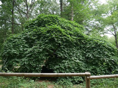
Arbre de la forêt de Verzy - Image : les Amis de saint Colomban PanoramicLes Faux de Verzy
This forest is located next to the chapel of St. Basle and therefore to the former monastery of St. Basle.
The ancient name of Fau was given to the beeches of the forest of Verzy. These tortuous trees have given rise to many questions and legends. It would seem that their shapes are the result of layering to obtain hedges around pastures, but will your imagination help the research?
More info: Wikipedia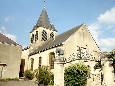
Église Saint-Martin à Trépail - Amis saint Colomban TouristSaint Martin's Church in Trepail
The nave of the church of Saint-Martin de Trépail dates from the 12th century with a later square chevet. It houses a beautiful reliquary of Saint Cucufat (4th century martyr) and Saint Aurelius.
Description
From the Place de la Basilique Saint-Rémi go down rue Chanteraine in front of you, cross the canal, turn left to go down the greenway at 180°, go under the bridge, follow the Coulée Verte de Reims for 9,600 metres, follow the red and white markings.
- In Sillery at the marina turn right on Jacques Cartier street, left on D8 Canada street, right on D 308 de Mailly street.
- After passing over the motorway and the railway, take the second road on the left, crossroads of 4 roads, follow red and white markings, asphalt road, on the right (150°) at the junction with asphalt road, on the left first dirt road red and white markings
- After passing the Moulin de Verzenay cross the D 26, left at the crossroads, straight ahead at the next crossroads to enter the forest, at the housing estate turn right into Avenue de Champagne, you leave the red and white markings, continue on a dirt track in the wood, straight ahead at each crossroads.
- Right in front of the vineyard, go along the sports field, go up in the wood, left at the crossroads of the forest road of Brise Charrette, left at the second road go to the observatory of Mount Sinai, take the forest road of Brise Charrette. At the crossroads, go straight on, cross the car park of Les Faux, take the second road on the left, go down towards the exit of Verzy, on the right take the road on the old railway, red and white markings.
- At the end of the stony path continue in the wood at the crossroads of the paths oblique slightly to the right to stay in the forest you leave the red and white markings, straight ahead in the vineyard, pass in front of the cemetery of Trépail, rue du Calvaire, straight ahead rue Saint-Martin you arrive at the church of Saint-Martin de Trépail.
- Departure : Saint-Rémy Basilica, 1 rue Saint-Julien 51 000 Reims
- Arrival : Saint-Martin Church, 6 rue Saint-Martin 51 380 Trépail
- Towns crossed : Grand Est
Altimetric profile
Report a problem or an error
If you have found an error on this page or if you have noticed any problems during your hike, please report them to us here: