4. from Léhon to Yvignac la Tour
During this stage, we will cross the Pays Poudouvre. A subdivision of the Bishopric of St Malo and although it is spoken in Gallo or French, its name, of Breton origin, means "land of waters". One will indeed skirt more or less large ponds in cultivated areas or in the woods. A roe deer may cross your path. In the villages, take the time to look at the traditional habitat made of stone or adobe.
6 points of interest
Abbaye de Lehon - alain.faverais CulturalLehon Abbey
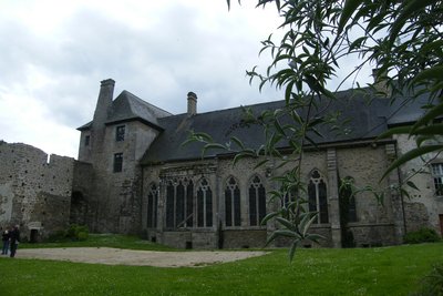
Léhon is a small city of character located in a loop of the Rance river at the foot of the city of Dinan.
It has the ruins of an old fortified castle and a Benedictine abbey dedicated to St Magloire whose foundation dates back to the 9th century. Built on the banks of the river Rance, one can discover the abbey church and the cloister, the monks' refectory and the monastery buildings which offer art exhibitions.
To find out more about it…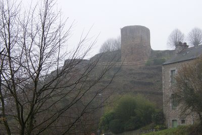
Château de Léhon - Amis Bretons de Colomban HistoricalLéhon Castle
The castle is already reported in 1034. It consists of a rectangular enclosure with eight towers. It was razed in 1169 by Henry II, King of England.
Its ruins were used to build the cloister.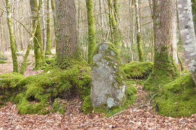
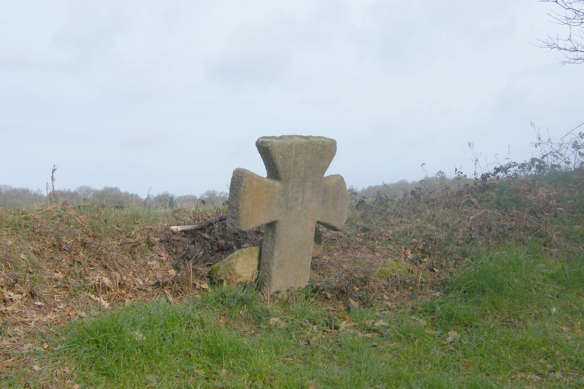
Une des bornes.. - Amis Bretons de Colomban HistoricalThe Path of the Seven Markers
This ancient medieval or Roman road (former Corseul-Rieux road) has not yet been the subject of archaeological research . It begins with the Cenefut cross (its base would date from the Middle Ages), then, over 1400m, it is marked out with monolithic markers from 1.00m to 1.60m high and separated by about 200m. There are still 6 markers.
Several hypotheses have been put forward as to their usefulness, but none has been judged satisfactory.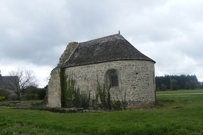
Chapelle de Lannouée - Amis Bretons de Colomban CulturalLannouée - Commandery of the temple
Built on a high point in the commune of Yvignac, the commandery is mentioned for the first time at the end of the 12th century.
With the suppression of the Order of the Temple La Nouée passes to the Order of St John of Jerusalem. It gradually became a central commandery.
The nave of the chapel disappeared in the 19th century. The choir (probably the oldest part) was restored in 1980.
The site was listed as a historical monument in 1976.
Beautiful wayside cross at the crossroads of Bas-Lannouée.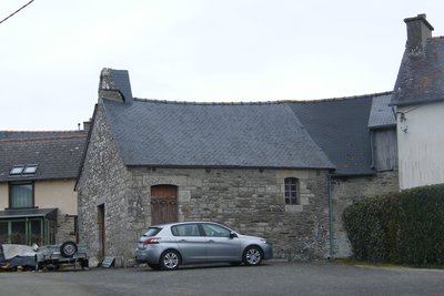
Chapelle St Firmin - Trélée - Yvignac - Amis Bretons de Colomban CulturalChapel of St Firmin
The chapel of St Firmin is located in the village of Trélée. Rectangular in plan, it dates from the 18th century, with reconstruction in the 19th century. It is attached to a farm building and contains several wooden statues. The village has many 17th and 18th century houses with engraved stones on the facade.
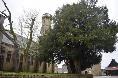
Eglise d'Yvignac la Tour - Amis Bretons de Colomban CulturalChurch of Yvignac-la-Tour
The old bell tower threatened ruin, it was decided in 1865 to demolish it and replace it with the 32m high tower which was completed in 1874.
In 1878 it is the church which threatens to ruin in its turn. It is decided to rebuild it. But on August 1, 1879 the church is classified as a Historical Monument and its restoration is undertaken in 1882. The work will be led by Corroyer, restorer of the Mont St Michel.
The precision "the tower" was recently added to the name of the commune of Yvignac to avoid confusion with Yffignac.
The visit of the tower is possible by appointment at the town hall.
Next to the church is a remarkable 750 year old yew tree. It is completely hollow. On August 15, 2017 a European record was set for the largest number of people in a hollow tree: 58 people managed to enter it simultaneously. At its feet was buried in 1794 the rector Guillaume Gauvin, who died during the Revolution in the village of Lannouée.
Description
From the abbey of Léhon, go up the village in the direction of the castle. Go along it and, after the roundabout, continue straight on by the Avenue de la Grande-Haye.
- Before a large bend to the right, turn left, the chemin de la Marotais. In the village, continue on the road which makes almost a half-turn. At the bend to the right, continue straight ahead by the chemin de l'enfer in the direction of St Suliac. At the end of the path, continue straight ahead by the rue de St Suliac. At the roundabout, continue along the rue des vignes.
- At the roundabout before the Epahd, take the path on the left, between the establishment and the housing estate. Continue on this path until the D765. Cross the departmental road and continue up to the village of La Porte Grissault.
- Take the road on the right, cross the access road to the castle of Vaucouleurs, and take the next track on the left.
- After having passed the locality and before entering the village of Trélivan, take the track on the left (small hiking path). Continue up to La Pleuvrie.
- After the village, the red one goes along the pond. At the first crossroads, and before passing on the dike, take the track at 45° on the right. Join the road to La Rivonnais and continue straight ahead up to the crossroads of La Tourtelais. Turn right.
- In the village of La Tourtelais, take the track which goes to the left. At the crossroads, leave the PR and take the track on the left. Continue straight ahead up to the road (ford the small brook).
- At the road, turn to the right on a few hundred meters and take the track on the right. After the pond, this track turns to the left while skirting the forest.
- At the crossroads marked by a granite cross, take on the left, the road of the seven milestones. At the next crossroads, turn to the left, cross the road D71 and continue up to the village of Haut-Lannouée.
- Cross the village and take the track on the right towards Bas-Lannouée. In Bas-Lannouée, cross the D62 and continue straight ahead. At the next crossroads, take the track on the left, in the direction of the wood and Lannouée. At the entrance of the village, take the path at 45° to the right and continue until the D62.
- Arrived at the D62 take the road on the right towards the wind turbines. Continue up to the D793. Take it on the right up to the next crossroads.
- Take the road on the left which runs parallel to the D793. After passing the Champ Robin, turn left towards the Cour Bague. Continue to the villages of Basse Boissière and Haute Boissière.
- After the village of Haute Boissière, take the track on the right towards the village of La Roche and then the village of Trélée. In the village of Trélée, turn right towards the Pont Renais. After the bridge, turn right and join the church of Yvignac la Tour (numerous 17th and 18th century houses with engraved stones on the facade).
- Departure : Abbey - 22100 - Léhon
- Arrival : Saint-Malo Church - Place des Terre-Neuvas - 22350 - Yvignac la Tour
- Towns crossed : Bretagne
Altimetric profile
Transport
The modes of transport in Brittany are grouped on Breizhgo and Mobibreizh.
Report a problem or an error
If you have found an error on this page or if you have noticed any problems during your hike, please report them to us here: