5. from Yvignac to St Méen
The Rance River has its source in the Dene Mountains. We'll cross it while it's still only a stream. The rivers we will meet after it, will now head south. The beginning of the stage crosses regrouped agricultural areas. Advantage: the paths are well marked out and the view is far away. Disadvantage: not much vegetation or birds.
The type of habitat will slowly change during this stage. Initially the houses are built in granite, then they will be built in adobe (construction based on earth and straw)-the base of the walls remaining in stone with a height proportional to the real or displayed wealth of the owners. Schist will start to appear at the end of the stage.
2 points of interest
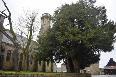
Eglise d'Yvignac la Tour - Amis Bretons de Colomban CulturalChurch of Yvignac-la-Tour
The old bell tower threatened ruin, it was decided in 1865 to demolish it and replace it with the 32m high tower which was completed in 1874.
In 1878 it is the church which threatens to ruin in its turn. It is decided to rebuild it. But on August 1, 1879 the church is classified as a Historical Monument and its restoration is undertaken in 1882. The work will be led by Corroyer, restorer of the Mont St Michel.
The precision "the tower" was recently added to the name of the commune of Yvignac to avoid confusion with Yffignac.
The visit of the tower is possible by appointment at the town hall.
Next to the church is a remarkable 750 year old yew tree. It is completely hollow. On August 15, 2017 a European record was set for the largest number of people in a hollow tree: 58 people managed to enter it simultaneously. At its feet was buried in 1794 the rector Guillaume Gauvin, who died during the Revolution in the village of Lannouée.
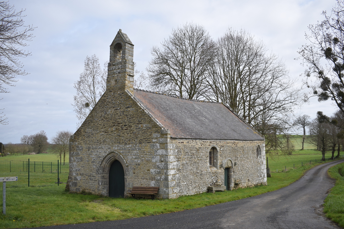
Chapelle de Bénin - Amis Bretons de Colomban CulturalBenin Chapel
Chapel in adobe dated 1609 and dedicated to St Yves and St Jean Baptiste. It depended on the commandery of Lannouée. A 15th century granite calvary stands on the cupboard. Part of the chapel has been privatized.
Description
From the church of Yvignac, take the rue du Guesclin in the direction of Broons. Take the first street on the left towards the fire station, then the street on the right towards the manor house (farm). Continue along the road, parallel to the D793.
- In the village of Biterne, take the road on the right, then the track on the left. Continue up to the railway, which you will follow a little to pass underneath and come back to the village of Lessard.
- Before the village of Lessard, take the road to the right and follow it to the end. Then turn right towards Ville Davy. In the village, take the track on the left. Follow it up to the place called Clémiclé, then the road D25.
- Arrived at the D25, take the track which leaves in front of you, slightly on the right. Join the D712 and take the bridge which crosses the four-lane road N12.
- After the bridge, take the track on the left and go up to the reservoirs. At the reservoirs, turn right. At the next crossroads, turn right and continue up to the place called "La Motte Blanche". After the houses, turn left and join the D46 at the Ville ès Noës.
- Take the D46 on the left, then, at the Ville Donnais, take the track on the right. Continue straight ahead until you reach the place called Ville Hazard and turn right.
- At the Calvary, take the track on the left. Follow it up to the place called Le Breuil and take the road on the left. At the crossroads, turn to the right and cross the river Rance. Continue until you reach Benin. Go past the chapel and turn left in the direction of Haut-Bénin. At the top of the hill, take the road on the right.
- Go towards Iffetz. At the crossroads after the village, turn left, then right towards the forest. At the crossroads take the track on the right and cross the forest. At the "lieu-dit de la Martinais", turn right and join the D125.
- Turn left up to the place called "Le Pied de Mouton". Turn left and join St Méen by the Haute Passière. After the supermarket, turn left and then turn right on the rue du Père Janvier and join the abbey.
- Departure : Place de l’église – 22350 – Yvignac-la Tour
- Arrival : Place du Général de Gaulle - Abbey - 35290 - St Méen-le-Grand
- Towns crossed : Bretagne
Altimetric profile
Transport
The modes of transport in Brittany are grouped on Breizhgo and Mobibreizh.
Report a problem or an error
If you have found an error on this page or if you have noticed any problems during your hike, please report them to us here: