1.
No need for mountain equipment for this 26km stretch of road.
Starting from the beach of Guesclin in St Coulomb, it joins Dol de Bretagne.
After a glance at the "bishop's rock" visible offshore at low tide and crossing the Clos Poulet (average altitude:40m), it first reaches the Duchess Anne dam (constant altitude of 9m) which borders the bay of Mont St Michel. It then crosses the marshes of Dol (altitude of 1m on arrival in Dol).
In case of mountain sickness, the Mont Dol (altitude 63m anyway!!!!), located at the end of the route, can be avoided.
5 points of interest
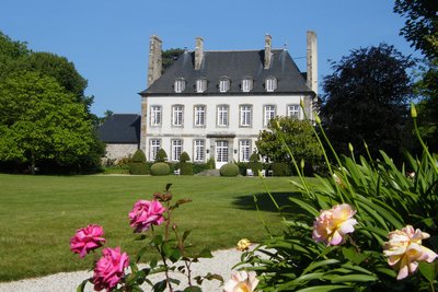
Malouinière de la Ville Bague - alain.faverais HistoricalMalouinière de la Ville Bague
The malouinières are country residences built by privateers and shipowners from Saint Malo at the end of the 17th century.
They are located less than 2 hours' ride from St Malo and many were built by Garangeau, a pupil of Vauban. There are more than twenty in the commune of St Coulomb.
The panoramic wallpaper in the living room, dating from 1820 and depicting Pizarre's arrival among the Incas, is a listed historic monument (manufactured by Dufour et Leroy).
The park also includes a dovecote and a semi-enclosed chapel dedicated to St Sophia.
To find out more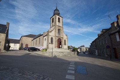
Église St Colomban - Amis Bretons de Colomban St ColumbanSt Coulomb's Church
In the church you can see
a monochrome wooden statue of St Colomban. It predates 1820 (previous church). The base of this statue contains two relics of St Columban, one of which was presented to Father Michel, the parish priest of St Coulomb, by Monsignor Ambrioso, Bishop of Bobbio, in July 2017, on the occasion of Columban's Day 2017 in Pianello Val Tidone.
the curragh: displayed in front of the gallery, it is used during the pardon procession and was made by a member of the association "Les Amis Bretons de Colomban" in 2015. The curragh is the ship used by the monks to travel between Ireland and the continent.
the banner: recently made, it evokes the arrival of St Colomban
The wooden bas-relief at the foot of the altar: This depicts the arrival of St Columban on the beach, awaited by the local people. It was made in 1953
the stained glass window of St Colomban in the choir, made in 1868 by the master stained glass artist Ernest Steizi.
At the end of the village in the direction of Cancale: statue of St Colomban dating from 2000 and donated by Martine Latimier and Bertram Wawera.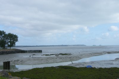
St Benoit de Ondes - Amis Bretons de Colomban TouristDuchess Anne's Dyke
The Digue de la Duchesse Anne is a dyke built on the ancient barrier beaches that separated the bay from the marshes of Dol de Bretagne. It stretches for around thirty kilometres as far as Ste Anne's chapel.
Construction probably began in the 11th century and continued over the following centuries, transforming the marshes into polders.
A comparison of the ground levels on the bay side and the polder side confirms that the bay has silted up.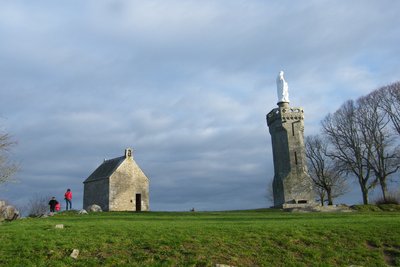
Le Mont Dol - alain.faverais PanoramicMont-Dol
Le Mont-Dol is a mound of 65m isolated in the middle of the 12000 hectares of the marsh of Dol de Bretagne. It was once surrounded by the sea.
Mammoth bones among others, have been discovered at the foot of the mountain.
At the top of the mountain, there is a chapel, a tower topped by a statue of the Virgin Mary looking towards Dol as well as several mills.
From the top, there is a magnificent panoramic view of the marshes of Dol and the bay of Mont St Michel, from Cancale to Granville.
The village with the church StPierre of the XIIth century is located at the foot of the mount.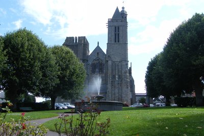
Cathédrale de Dol de Bretagne - alain.faverais CulturalCathedral of Dol de Bretagne
Dol de Bretagne was the episcopal see of St Samson, one of the seven founding saints of Brittany. The cathedral of Dol is a stage of the "Tro Breiz".
The cathedral of Dol de Bretagne is in Gothic style. It was erected between 1200 and 1280 and replaced a burnt-out Romanesque building. One of the towers has remained in the state of project.
One of the peculiarities of this cathedral is its double shaft; an external cylindrical shaft 90cm in diameter and 12m deep and an internal parallelepipedic shaft of 0.80X0.60m recently discovered. These 2 shafts are connected by a gallery 4m long and 1.80m high at 11.50m deep.
On the forecourt of the cathedral is exposed a granite vessel, "Maen vag" (the granite vessel). It recalls the legend that the Irish monks, including St. Samson, landed on our shores in stone troughs. This boat, sculpted by Jean Yves Menez in 2000, is 4m long and weighs 3.5 tons and floats ... It even crossed the Rance River!
Nominoë, whose statue stands in front of the cathedral is one of the first creators of a unified and independent Brittany. He erected Dol as the religious metropolis of Brittany and was crowned King of Brittany by St Samson in 848.
The cathedraloscope, located next door, tells the history of cathedrals and their construction.
The city of Dol has an important military (ramparts) and civil (half-timbered houses) heritage.
Learn more about the catheteroscope...
Description
Departure along the coastal road, direction St Malo
- At the top of the hill, take the path on the right which forms a loop and allows you to avoid road traffic.
- Cross the coastal road and take the departmental road in the direction of St Coulomb.
- After the apple tree field, take the path on your right. It leads you to the place called "l'Hermitage" (trace of an old hermitage?). Continue along the street and cross the D74.
- Turn left, go through the village of La Ville-Huet to the wall of the Ville-Bague park and head towards the town of St-Coulomb.
- At the exit of the village, turn right towards the cemetery. Continue to the Calvary, and turn left, rue du Fresne. Continue to the village of Fresne.
- Turn left, cross the crossroads of the Croix Blanche (calvary in granite painted white) and continue to the place called Bois du Père.
- After the place called "Bois du Père" take the path on the right and follow it to the road and turn right.
- Turn left onto the exploitation road. Follow it to the outskirts of Cancale.
- Cross the D76 and after about ten meters, take the path on the right (GR34). Follow this path until you reach the road to the bay.
- Take the road towards the Karting, then the red/white marked path on the left. It is also possible to continue along the bay road until the entrance of St Benoît des Ondes.
- From St. Benoît the red/white marked path follows the Duchess Anne's dike which separates the bay from the Dol marshes.
- Turn right and follow the red/white marked path to Mont Dol.
- The red/white marked path goes up to the top of Mont Dol but it can be bypassed by the road. Follow it until Dol.
- Departure : Anse du Guesclin, St Coulomb
- Arrival : Cathedral of Dol de Bretagne
- Towns crossed : Bretagne
Altimetric profile
Transport
The modes of transport in Brittany are grouped on Breizhgo and Mobibreizh.
Access and parking
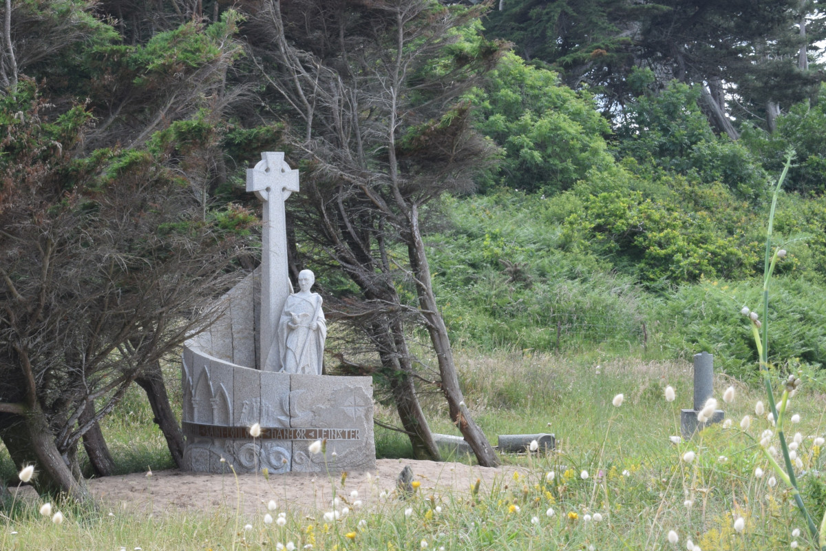
Access to the monument recalling the landing of St Colomban on the mainland by the coastal road D201 from St Malo to Cancale.
Small car park nearby
Report a problem or an error
If you have found an error on this page or if you have noticed any problems during your hike, please report them to us here: