Couches to Autun
Bourgogne-Franche-Comté
12. Couches to Autun
Difficult
7h30
30,7km
+501m
-480m
Step
Embed this item to access it offline
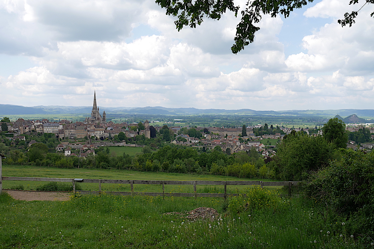
A day in contact with nature before discovering the rich heritage of Autun. If you are a heritage lover, we advise you to do this stage over two days with a break in Andully. The second shorter day will allow you to discover the heritage of Autun.
7 points of interest
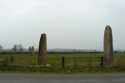
Menhirs d'Époigny - Wikipédia image Félix Potuit HistoricalThe menhirs of Epoigny
The megalithic ensemble of the 4 menhirs of Epoigny is the most important in Burgundy. The menhirs were erected on the edge of a vast plateau overlooking the Dheune valley.
The first menhir is 7.30 m high, 5.60 m of which is above ground. Its southern face is decorated from top to bottom with several engravings: an anthropomorphic representation about 0.70 m high.
More information Wikipédia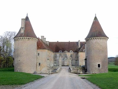
Château d’Épiry - Site internet www.chateauxdebourgognefranchecomte.com HistoricalChateau d'Épiry in Saint-Émilian
The castle of Epiry is located 8 kilometres from the start of Couches on the Via Columbani, masked by a farm that must have depended on the estate.
Having preserved its four round towers from medieval times, the castle of Epiry surprises by its location on the hillside. A stronghold as early as the 12th century, its military character was reinforced by the construction, during the 13th or 14th century, of the four towers incorporating a keep built earlier, linked together by curtain walls, pierced by defensive openings, and surrounded by a moat. From the 15th century onwards, the towers were pierced with small windows, while a chapel was erected nestling against the south-east tower: its flamboyant Gothic cross vault is surmounted by the Rabutin's coat of arms. A little later, the main building framed by the two north towers was illuminated by mullioned windows with irregular arrangement.
Château des Rabutin since at least the 16th century. Epiry saw the birth on 3 April 1618 of Sieur Roger de Bussy-Rabutin, first cousin of Madame de Sévigné, who was noticed by Louis XIV at his court before being expelled from it.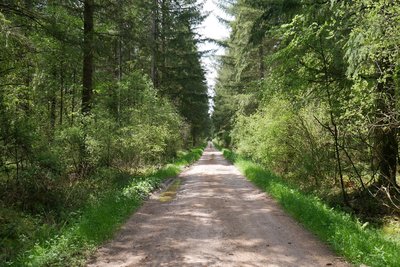
Forêt de Planoise avant Autun - Amis saint Colomban PanoramicThe Planoise Forest, Autun
The Via Columbani crosses the Planoise forest and is the largest in the department of Saône-et-Loire. Take the time to discover the species of trees and the charm of the clearings. Walking on well-maintained paths but frequented by cars.
At the exit of the forest the church of Fragny, located on the Via Columbani, is waiting for you to take a break. It cannot be visited but we invite you to read the story of the parish bursar's office of Fragny in 1891, created in the depths of the woods by the parish priest of the time for woodcutters; an extract of the text is available online :
... The few inhabitants scattered over this poor corner of land, are harsh and almost uncultured like their climate and soil. Lost between two immense forests, it is from wood that they derive their work, their subsistence and their main resources. They are a little ploughmen, a little stockbreeders, but above all lumberjacks, charcoal burners and clog makers; real men of the woods, having with the city only rare and difficult relations, without intellectual culture, almost without moral culture, at the mercy of a few retailers who abuse it...
The Fragny parish bursar's office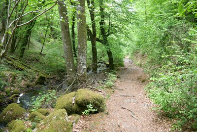
La Via Columbani longeant le ruisseau de Brisecou - Amis saint Colomban PanoramicThe brook of Brisecou, Autun
Before arriving in Autun you will discover the Brisecou brook and its waterfall.
The history of Brisecou goes back to the end of the Middle Ages. There is no mention of a waterfall yet. It does not exist. We learn, however, that there was a grinder (a mill). It had been sold on 8 February 1475 to Jean Champriet, marshal, living in Autun. He undoubtedly manufactured there blades of scythe then, perhaps weapons. The mill was then abandoned for almost two centuries.
In the 18th century, it was restored and put back into service by a man named Gresset to make scythes as well. His nephew continued the activity until he left to set up as a gunsmith in Aix-en-Provence.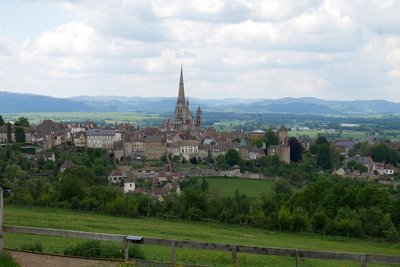
L’imposante cathédrale domine la ville d’Autun - Amis saint Colomban TouristSaint Lazarus Cathedral in Autun
A first cathedral was built in Autun from the 5th century, later consecrated to Saint-Nazaire (a 14th century chapel remains). The church of Saint-Lazare (dedicated to the saint Lazare of the Gospel) was planned by the bishop of Autun, Étienne Ier de Baugé, in order to preserve the relics which were believed to be those of this saint, but which were in fact those of Saint Lazare of Aix. These relics were kept until then in Marseilles.
The construction of the building began around 1120 by Etienne de Baugé, it was completed in 1146, and the porch a few years later. It is built on the model of the abbey church of Paray-le-Monial. The church has, as in Cluny and Paray, a broken barrel vault, built shortly after its consecration as a cathedral, since buttresses were added at that time. A spire was built in 1469 by Cardinal Rolin (the son of Chancellor Rolin), above the transept crossing, in place of a Romanesque bell tower destroyed by lightning. It is 80 m high. In 1476, Cardinal Jean Rolin donated the Marthe bell, the cathedral's bumblebee, which weighs 3,360 kg and has a diameter of 1.69 square metres. It still rings alongside three other bells dating from 1854.
The portal is the most remarkable element of the cathedral. It was made to represent the Last Judgement, by Gislebert, who signs his name at the feet of Christ.
For several years now the cathedral has been undergoing restoration work which will restore the building to its full majesty in the image of the tympanum restored in 2009.
More information: Wikipedia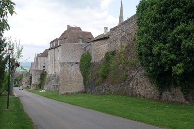
Les remparts gallo-romains d’Autun - Amis saint Colomban HistoricalThe best preserved Gallo-Roman ramparts in all of Gaul.
The enclosure is about 6 kilometres long and is one of the best preserved in all of Gaul since more than two thirds of its layout still exists. The walls have a homogeneous thickness of about 2.50 metres, which has enabled them to act as retaining walls. A 2007 study showed the existence of 48 sections of curtain wall (roughly the walls) and a further 30 towers, of which the original number is estimated at 57, the regularity of the layout and construction allowing this estimate to be made. The walls are thought to have been completed during the Tiberian period. For the southern tip of the enclosure at the level of the Ursuline tower, seems to be a later extension, probably from the 3rd century, but without certainty.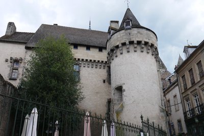
Portes des Bancs, Autun - Amis saint Colomban HistoricalLa Porte des Bancs, Autun
The only opening of the upper town to the north, the gate of the benches owes its name to the stalls of butchers who were obliged to cut meat in the Middle Ages in a neighbouring room.
Its primitive state in the 5th century is poorly known. From the 12th-century door there remains on the left the groove where the closing harrow used to slide, as well as two walled doors. In 1360 a new gate flanked by two towers was built in front of the previous one, the left tower and the drawbridge apron remain.
Information panel on the site
Description
Leave the church of Couches on the left, rue Saint-Martin, first right, second right rue de la Bergerie.
- Cross the street and take the asphalt road between the two houses, at the crossroads on the right, after 1800 meters turn left onto a grassy path.
- In front of the calvary on the right then on the left in front of the farm take the dirt road on the left, first road on the right at the entrance of the woods
- Left on Chemin de Précloux, right on Route de Saint-Pierre, D131
- After the bridge on the TGV road, turn left on the grazing path, right in front of the farm, cross the road to Saint-Firmin D43, straight on the forest road, at the crossroads turn right in front of the farm, stay on the road, Route de la Croix Forêt, after 1900 meters left at Cours Barault, left Route de l'Étang de Porleux
- Les Cerisiers on the left and right exit the hamlet, right at the subdivision, Route de la Verrerie, entrance Antully, rue du 19 mars 1962, cross the village, first tarmac road on the left, Route de Porrots, in Les Porrots on the left, second on the right on the D680 first forest road on the left. After the crossroads, turn left then right, route le Forêt de Planoise D287.
- At the crossroads with D120 straight ahead and first dirt road on the right, crossroads with chemin de Montmain on the right, left on D120
- First road on the right towards Cascade de Brisecou, signposted path following the river, at Couhard, chemin de la cascade on the right along the car park, take the dirt road.
- Turn left on Chemin des Ragots at the roundabout straight ahead, rue Gaston Joliet, after the cemetery entrance turn left, short street then twice left, rue Sainte-Anne, at the crossroads straight ahead, rue Bouteiller, first left, rue Chanoine Trinquet you arrive at the Saint-Lazare cathedral.
- Departure : Saint-Martin Church, 2 place de l’Église, 71 490 Couches
- Arrival : Saint Lazarus Cathedral, place du Terreau, 71 400 Autun
- Towns crossed : Bourgogne-Franche-Comté
Altimetric profile
Transport
Report a problem or an error
If you have found an error on this page or if you have noticed any problems during your hike, please report them to us here: