Verdun-sur-le-Doubs to Chalon-sur-Saône

Bourgogne-Franche-Comté
10. Verdun-sur-le-Doubs to Chalon-sur-Saône
Medium
6h
21,8km
+129m
-128m
Step
Embed this item to access it offline
From Verdun-sur-le-Doubs you cross the grain fields of the very fertile Saône plain. You reach the right bank of the Saône river which accompanies you to Chalon-sur-Saône.
2 points of interest
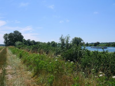
Une péniche descend la Saône à côté de la Via Columbani - Amis saint Colomban TouristNavigation on the Saône
While in Roman times the trade on the Saône, especially in wine, experienced an important movement from south to north, the period that followed was marked by a trade down the Saône, taking advantage of the current with the help of oars. On the way back up, the empty boats were grouped together in horse-drawn convoys.
When steam appeared around 1825, tugboats could lower and raise the convoys.
In the 19th century, the main boats in use on the Saône were the Penelles, with the bow and stern raised, the Savoyardes with the square and raised nose, very low on the water, and the Ciselandes, narrower than the Savoyardes. Around 1880, the introduction of the Freycinet gauge locks and canals in France led to the appearance of a new wooden boat, the Péniche du Nord.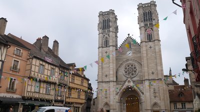
La façade de la cathédrale Saint-Vincent de Chalon-sur-Saône - Amis saint Colomban TouristSaint-Vincent Cathedral in Chalon-sur-Saône
The origin of this cathedral remains very vague. There is talk of the 4th or 5th centuries. What is known is that the first church was built on the ancient Gallo-Roman rampart and that it occupied the place of an ancient temple.
The present cathedral was built between 1090 and 1522. We owe its chronology to Abbot Salis (who died in 1970), who knew all about Saint Vincent (patron saint of winegrowers) and who had devoted part of his life to unraveling its mysteries. From this chronology, two main periods emerge: the Romanesque and the Gothic ages.
Description
In front of the church of Verdun-sur-le-Doubs, turn right rue de la République, third street on the right, rue de Verjus D439
- After 3,300 metres take a dirt road on the left after the bridge over the brook, turn right and then left, direction Mont
- Left, rue de la Grand Cour, right then left, rue du Haut de Mont
- Left at the D139 junction, route de Damerey
- After 2,500 meters take a dirt road that follows the bank of the Saône River.
- At the port of Allériot, cross the square, left then right, rue du Port, rue du Bois Verdenet, rue de Vertembeau
- At the crossroads turn right, rue des Tuileries, second street on the right, rue des Huns
- At the crossroads, turn right then left, go along the campsite, pass under the bridge of the D5a, rue Julien Leneveu, stay on the banks of the Saône.
- Take the footbridge on the arm of Chavannes, cross the Génise with the bridge of the rue de Strasbourg, place Thévenin, quai de la Monnaie, take the Saint-Laurent bridge, on the right quai de la Poterne, second street on the left, rue de la Poissonnerie, you arrive at place Saint-Vincent.
- Departure : Saint-Martin Church, 1 rue de la République, 71 350 Verdun-sur-Le-Doubs
- Arrival : Saint-Vincent Cathedral, place Saint-Vincent, 71 100 Chalon-sur-Saône
- Towns crossed : Bourgogne-Franche-Comté
Altimetric profile
Transport
Report a problem or an error
If you have found an error on this page or if you have noticed any problems during your hike, please report them to us here: