Annegray to Ronchamp
Bourgogne-Franche-Comté
1. Annegray to Ronchamp
Medium
6h
23,1km
+502m
-522m
Step
Embed this item to access it offline
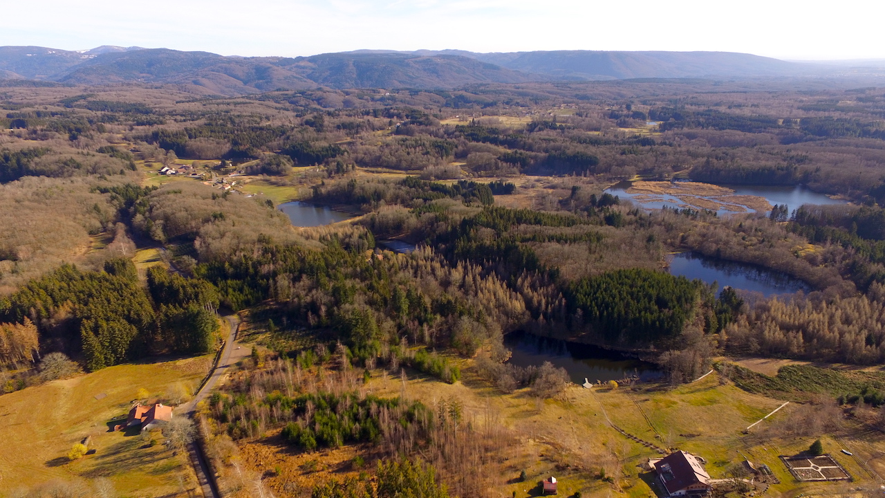
The plateau of the 1000 ponds offers itself to you with its biodiversity. Take the time to admire the landscape, the vegetation. Whatever the season and the weather, you will be charmed by this walk. Remain vigilant on your route, the paths are numerous and an error of appreciation can quickly occur.
4 points of interest
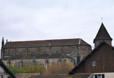
L’église romane avec son clocher et la nef de l’église du 19e siècle à Mélisey - Amis saint Colomban TouristChurch of St. Peter and St. Paul in Melisey
The church of Saint-Pierre and Saint-Paul de Mélisey dates from the 12th century. Of the Romanesque building, only the choir remains, whose three oriented apses are relatively well preserved. During work on the burials and two carved blocks used in reuse were discovered at the back of the chevet.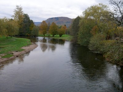
L’Ognon à Mélisey - Amis saint Colomban St ColumbanThe river Ognon in Mèlisey
The river Ognon, which runs through the town of Mélisey, is mentioned in the life of Saint Colomban. Jonas de Bobbio tells of a conflict between the monk Gall and his master Colomban. The latter had asked Gall to fish for fish in the Breuchin river which passes in front of the monastery of Annegray. Gall disobeyed and went to fish in the Ognon, he didn't catch any fish and had to go back to fish in the Breuchin to bring back an abundant catch.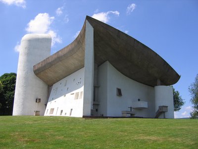
Chapelle Notre-Dame du haut - amis saint Colomban TouristNotre-Dame-du-Haut Chapel in Ronchamp
Tradition tells that the Bourlémont hill was occupied by a pagan temple during antiquity, probably transformed into a Christian place of worship in the early Middle Ages.
The first trace of a Catholic building dates back to the 13th century. It is a place of pilgrimage under the name of Our Lady of the Nativity. The parishioners of Ronchamp and the surrounding area gather on the hill to pray.
In 1737, the relocation of the parish church to a new building in the centre of Ronchamp heralded a decrease in the use of the chapel except for pilgrimages. As in all the countryside, the old places of worship are still frequented like the chapel of the Haut. This attachment of the parishioners manifested itself by the purchase of the chapel after the Revolution, to make it a private property, which is still the case today.
At the beginning of the 20th century, faced with the dilapidated state of the chapel, a consequence of lightning and a fire in 1913, the Archbishop of Besançon proposed to rebuild this place of pilgrimage. The new chapel was damaged during the 1944 bombings of the mining town.
The descendants of the first owners of the chapel joined together in a real estate company to rebuild the building. Consultations with the diocese of Besançon were to succeed and an architect Charles-Édouard Jeanneret-Gris, better known under the pseudonym Le Corbusier, was hired. He fell under the charm of this hill and its panorama.
Le Corbusier will use the technique of reinforced concrete, not very common at that time for this type of building. The construction began with the roof of the chapel placed on a forest of wooden scaffolding that appealed to the visitors of the time.
The interplay of interior colours, skilfully chosen by the architect, and the roof symbolising the flight of a bird won over the public at the inauguration in 1955.
There is an entrance fee to visit the building.
More Informations Notre-Dame-du-Haut Chapel website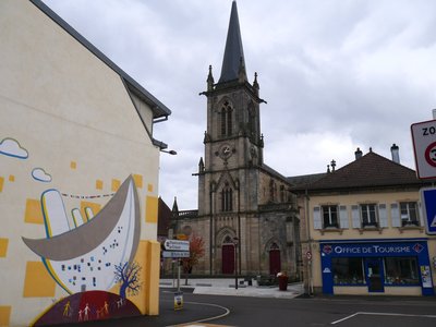
L’église Notre-Dame du Bas à Ronchamp - Amis saint Colomban TouristNotre-Dame-du-Bas Church in Ronchamp
The history of this church, in the centre of the town of Ronchamp, must be told in conjunction with that of the Notre-Dame-du-Haut chapel on the Bourlémont hill.
An 11th century document attests the presence of a Notre-Dame chapel on the hill, attached to an abbey in Besançon. The Lords of Ronchamp found the place of worship too remote and were authorised by the archbishopric to build a Saint-Hubert chapel in their castle during the 15th century.
A new parish church was built in 1737 to replace the Saint-Hubert chapel.
During the 19th century, major alterations were made to the lower church, which is the building we see today. While the chapel of the upper church is subject to storms and low attendance outside the pilgrimages to Notre-Dame.
Description
Pass in front of the Saint-Colomban chapel on the left in front of the Town Hall, on the right at the crossroads towards Le Sceupt, on the right at the crossroads towards Les Échaux
- Continue to the Étang de Plate Pierre (asphalt road) After 200 m take a path on the left at 45°. After 400 m, turn left and follow the path along a pond. Then pass between two ponds in the direction of La Champagne.
- At the crossroads, take a hairpin path on the right and go down to the ruins.
- Turn left at the asphalt road junction and turn right at the cross. Follow this road for 700 m and take the road on the left towards Moulin Grillot.
- At the entrance to this hamlet take a goose-leg path on the right, join a forest road, turn left and head towards the Granges Baverey. Go past the gîte rural and join the D 293,
- Turn right for 300 m, drive past the campsite, first road on the left. After 300 m take a path on the right towards La Conche. Follow the path in the direction of Montaujeu.
- At the crossroads on the right, after 200 m, turn left. Pass between two ponds, go straight ahead along a new pond, turn right, go along a pond and join the forest road.
- Turn left and join Melisey. Arriving on the D486, turn right then left and join the church, go around the church by the south, go down, turn left, cross the fairgrounds to take the bridge over the Ognon.
- Turn left at the exit of the bridge, rue de l'église, go around the church on the right, at the crossroads in front of the town hall, stay on your right Chemin des Lapierres. Cross the Fourchon river, continue on the road and go straight ahead.
- Take the second road on the right to reach the Plaines Fouillies, turn left on the tarred road Chemin des Granges du Bertey, Chemin du dessous des Granges, Chemin de la Verrerie go towards the Granges Guenin. Go straight on, follow a path to a reservoir.
- Continue straight on for 150 m and take the path on the left until Mourière. Take the asphalt road on the left then at the crossroads on the right, continue for 300 m. Turn right and go past a sawmill then take the first road on the left (follow the red and white rectangle to the Chapel Notre Dame du Haut).
- Continue on an uphill path and arrive on the D 264 which you will follow on the right to reach La Chapelle Notre-Dame du Haut. In front of the chapel's reception centre, turn left at the end of the car park, go down the Chemin de Croix towards the cemetery, pass under the railway line and you will arrive in front of the Notre-Dame du Bas church.
- Departure : Saint-Colomban Chapel, Annegray, 70 310 La Voivre
- Arrival : Notre-Dame-du-Bas Church, 1 rue de l’Église, 70 250 Ronchamp
- Towns crossed : Bourgogne-Franche-Comté
Altimetric profile
Report a problem or an error
If you have found an error on this page or if you have noticed any problems during your hike, please report them to us here: