Bremm to Treis-Karden
Rheinland-Pfalz
6. Bremm to Treis-Karden
Medium
6h
23,3km
+823m
-844m
Step
Embed this item to access it offline
A stage that begins with the ascent on a plateau, with a vast holiday complex, to descend the banks of the Moselle with a very beautiful heritage in Cochen.
6 points of interest
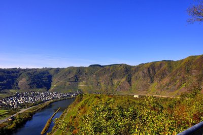
Vignoble Bremm Calmont - Wikimedai Commons H.Peierl - PanoramicBremm Calmont: the steepest vineyard in Europe
The mountain "Bremmer Calmont" rises above the Moselle village of Bremm, which was first mentioned in history in the mid 11th century, has almost 1,000 inhabitants and is adorned with half-timbered houses.
At 380 metres high and with a slope of up to 68 degrees, it is considered to be the steepest vineyard in Europe. As part of the project "Monastery of Calmont - Stuben - St. Petersburg" of the state programme "WeinKulturLandschaft Mosel" (Mosel of Wine Culture and Landscape), an eventful and exciting circular hiking trail with an alternative via ferrata has been created in this Riesling vineyard, which is about 5 kilometres long.
The trail, which is 200 to 300 metres high, starts behind the Moselle bridge at the end of Eller, a district of Ediger-Eller, in the direction of Bremm. At the railway station in Eller, you go up to the middle of the vineyard. Then you cross the vineyard to Bremm. In some places the path is secured with steel cables, clamps and ladders.
Winegrowing in the Calmont goes back to written sources for the period around 1000. However, there is further evidence that wine was already being cultivated here at the end of antiquity, i.e. in Roman times. The Romans are said to have given this vineyard the Latin name "Calidus mons = hot mountain". Other sources derive the name "Calmont" from "Calvus mons", which means "bare mountain".
The warm climate and the geological and topographical characteristics of Calmont generally produce a fruity wine, rich in minerals and acid. While the area under vines was about 25 hectares 30 years ago, it has decreased to 10 to 11 hectares today. 60 to 70 winegrowers harvest only 35 to 50 hectolitres per hectare on small and very small plots to the benefit of the quality of the wine.
A journey back to Roman times awaits you in a dream location at the top of the rocky promontory. There, at an altitude of 378 m, is a temple of Gallo-Roman customs, which was discovered and rebuilt in 2005 during excavation work.
Further information: Mosel.de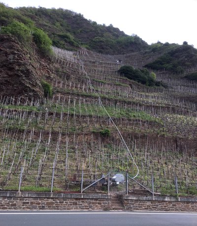
Vignoble du côteau de moselle - Amis de saint Colomban CulturalThe Moselle vineyard clinging to the mountains
The vineyards of the Moselle valley have an extremely steep slope and the harvest is carried out thanks to monorails that punctuate the different plots.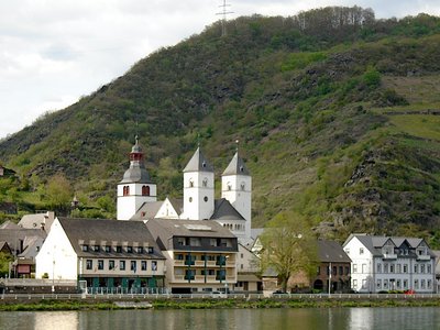
Collégiale Saint Castor à Tries Karden - Amis de saint Colomban CulturalSaint Castor's Church in Treis-Karden
The collegiate church is from the Romanesque period. It is the most important church between Trier and Koblenz.
Castor of Karden († 400), a pupil of Maximin of Trier, probably came from Aquitaine.
In the 4th century he was a priest of a primitive Christian community. After his death, Castor was buried in the present abbey quarter. His masonry tomb, originally built under a wooden memorial, was discovered during excavations in the north courtyard in front of the monastery manor house.
Construction of the present collegiate church began in 1186 on the foundations of the old building. At that time, the building took its present form, with a Romanesque choir, a beautiful apse, side towers and a transept. The nave, which is more recent, is in Gothic style, contrasting with the rest of the collegiate church. The west tower, dating for the most part from 1120, was completed in 1699 with a sixth floor topped by a bulbous bell tower.
In 1802, when Napoleonic troops occupied the area, the priest's college was dissolved, while most of its possessions were sold. Today, a museum in the abbey building of Karden traces the history of the monastic community of the village, as well as that of the region in general.
The high altar of the collegiate church has an altarpiece dating from 1425, presenting the Adoration of the Magi. A beautiful tomb and the reliquary are worth a visit.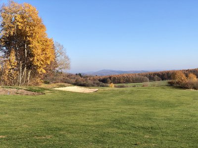
Golf sur les hauteurs de Cochem - Les amis de Saint Colomban TouristGolf Club de Cochem Mosel
At the start of your stage and after climbing into the forest you will discover a magnificent golf course on the plateau above Cochem or Ediger-Eller, bordering a holiday park.
The Cochem golf course has an 18-hole championship course (Par 72) as well as a 9-hole executive course (Par 31), which can also be played without a licence and without membership of the DGV.
The spacious and modern training area includes a practice course with over 50 teeing areas, 30 of which are covered, some of which are lit in the evenings.
There are also two putting greens, practice bunkers and a pitching and chipping area.
More info at: Golf Club Cochem Losel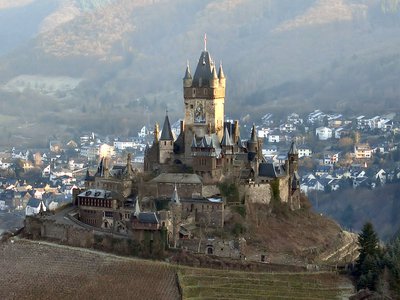
Le Chateau de Reichsburg - Wikimedia Commons Holger Weinandt HistoricalReichsburg Cochem
The Reichsburg Cochem was probably built around the year 1000. Successively seat of the Counts Palatine, then imperial residence of the Hohenstaufen dynasty.
Wikipedia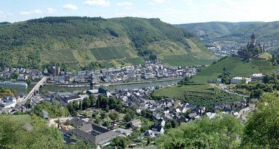
Panorama de la ville de Cochem - Wikimedia commons Holger Weinandt PanoramicPanorama of the town of Cochem
The chairlift takes you to one of the highest vantage points above Cochem, the Pinner Kreuz.
Description
Departure from Sainkt-Laurentius church, join the path on the Moselle river bank, turn left
- After the railway bridge in Eller, turn left at the car park, straight ahead up Bachstrasse, left at the roundabout of the Golf-Club Cochem
- Turn right at the crossroads, go down towards the Moselle, in Sehl turn left in front of St. Antonius Church, Joseph von Lauf-Strasse, keep left on Joseph von Lauf-Strasse, continue into the forest, turn right again
- At the Drei Kreuze crossroads go straight on towards Cochem, Schoss-Strasse, go down towards the city centre, left at the Herrenstrasse crossroads cross the square straight on Bernstrasse
- After the church, first street on the right, cross Carlfritz-Nicolay-Platz on the left, cross the Skagerrak-Brücke bridge on the right to cross the Moselle, on the right on the bridge take the stairs to Uferstrasse, on the right pass under the bridge and then on the left pedestrian path on the river bank.
- At the next Nordbrücke bridge, turn right up to the road, without crossing the Moselle, K 60 Moritzburger Strasse, left after the Markweg swimming pool complex, straight ahead at the roundabout follow the Moselle river bank
- In Tries-Karden continue on Am Laach, right at the crossroads Am Kalkofen, straight on at the crossroads Forststrasse, left at Am Acker you arrive in front of the St. John the Baptist church in Tries-Karden.
- Departure : St. Laurentius Church, Kirchestrasse 1, 56814 Bremm
- Arrival : Church of St. John the Baptist, Am Plenzer 4, 56253 Treis-Karden
- Towns crossed : Rheinland-Pfalz
Altimetric profile
Transport
Report a problem or an error
If you have found an error on this page or if you have noticed any problems during your hike, please report them to us here:

