1. From St Malo to St Coulomb
9 points of interest
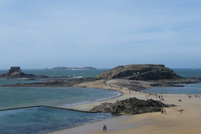
Le Grand Bé, le Petit Bé et Cézembre au loin depuis les remparts - Amis Bretons de Colomban HistoricalLe Grand Bé
The Grand Bé is an islet at the foot of the ramparts of St Malo, accessible at low tide. It was used for quarantine and fortified by Vauban. The presence of a German firing post during the Second World War led to its bombardment by the Allies. In 1823, François René de Chateaubriant asked to be buried on a promontory on this islet. This was done on 18 July 1848. He remains at the top of the cliff, eternally turned towards the sea and the storm.
To find out more...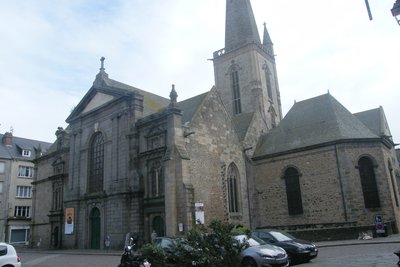
Cathédrale de St Malo - Amis Bretons de Colomban CulturalSt-Malo's Cathedral
St Malo cathedral is dedicated to St Vincent. Following on from St Peter's cathedral in the city of Aleth, Jean de Châtillon transferred the seat of the bishopric of St Malo to this cathedral in 1146. This was abolished in 1801 and divided between the bishoprics of Rennes, Vannes and St Brieuc.
Because it is built into the rock, the building slopes steeply towards the choir. There is a strong contrast between the very dark Romanesque nave and the luminous Gothic choir, but the whole has undergone many changes, including in 1944, when the spire was hit by shellfire and collapsed onto the Sacré Coeur chapel, with incendiary shells doing the rest. Reconstruction of the building and its tower was not completed until 1972.
On the left side of the choir is the tomb of Jean de Châtillon (or Jean de la grille, named after the position of the tomb near the gate). The tombs of Jacques Cartier and Duguay Trouin are in the chapels of the ambulatory.
Outside, on the right-hand side of the cathedral, are the remains of the former Romanesque cloister, which were found during excavation work after the Second World War. Only the column and capital on the left and the two on the right are original; the others were added during the post-war reconstruction.
For more information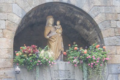
Notre Dame de la Porte dans sa niche - Amis Bretons de Colomban CulturalOur Lady of the Great Gate
The Grande Porte is one of the old main entrances to the fortified town of St Malo. It is also known as the Porte Notre-Dame.
A copy of a statue of the Virgin and Child is located in a niche above the gate.
The original was moved to St Malo Cathedral in 2003. The statue, made of painted limestone, dates from the 15th or 17th century. Its origin is unknown. Beheaded during the French Revolution, it was blown up by a shell during the liberation of St Malo in June 1944.
Many people in St Malo consider her to be the town's protector.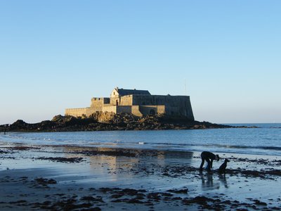
Le fort National à marée basse - Amis Bretons de Colomban HistoricalThe forts of St Malo Bay
The bay of St Malo has many rocks and islets. While these reduced access to the port to a few passes, they also provided hiding places for enemy ships (English and Dutch). Vauban ensured the city's protection by building several forts at sea, which could be used to close off the passes with their crossfire. St Malo was never taken.
The La Conchée fort, located 3.7km from the coast, is the most impressive of these.
Fort National is located on the Islet rock, accessible at low tide in front of the ramparts. Originally called Fort Royal and then Fort Impérial, it was built in 1689 by Siméon Garangeau to Vauban's plans. It is open to the public (when the flag is raised).
To find out more
Rochers Sculptés de Rothéneuf - Amis Bretons de Colomban CulturalSculpted Rocks of Rothéneuf
In 1894, having become deaf, Abbé Fouré had to leave his post as rector and retire to Rothéneuf.
For thirteen years, he sculpted more than 300 bas-reliefs in the rocks overlooking the sea. Paralysis forced him to stop his work.
These sculptures were subjected to the sea spray and the assaults of the sea. They are deteriorating rapidly. An association is trying to save them.
You have to pay to enter the site via the restaurant, but you can get there from the beach (the site is located on maritime land).
A little further on, the little chapel of ND des Flots overlooks the sea.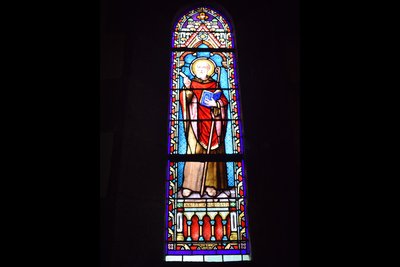
Vitrail de St Colomban dans l’Église de Rothéneuf - Amis Bretons de Colomban St ColumbanChurch of Rothéneuf - Stained glass window of St Colomban
Stained glass window visible from the gallery. Signed by Jean Clamens of Angers in 1897 (the gallery is accessible from the back of the church).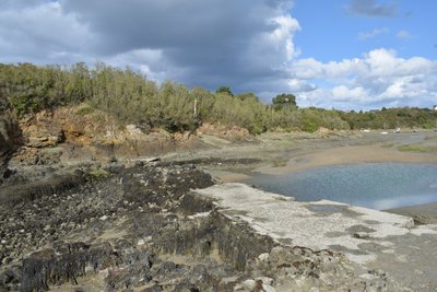
Moulin à marée – Anse du Lumin - Amis Bretons de Colomban HistoricalLupin Tide Mill
At the end of the Lupin cove (the name of the part of the cove in the commune of St Coulomb - the part in St Malo is called the "Havre de Rothéneuf"), you can make out the ruins of an old tide mill, one of the few in the region not to be found on the Rance. Mentioned in documents dating back to 1180, it could be one of the oldest in Brittany. It is the forerunner of the hydroelectric dam on the Rance.
The landscape of this cove is highly variable: at high tide, it presents a magnificent sheltered stretch of water; at low tide, only a trickle of water crosses it. It is a haven for birds.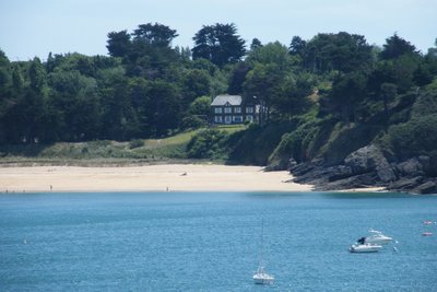
Villa de Roz Ven - Amis Bretons de Colomban HistoricalRoz Ven
Villa Roz Ven is tucked away in the dune above La Touesse beach.
In 1910, it was acquired by Colette and her friend. The writer lived there until 1924. She wrote several novels here, including "Le blé en Herbe".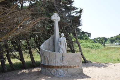
Croix de St Colomban - Amis Bretons de Colomban St ColumbanCross St Colomban de l'anse du Guesclin
Inaugurated by Loïc Levillain, Mayor of St Coulomb, and blessed by Monseigneur D'Ornellas, Archbishop of Rennes, on 20 July 2019 during the pardon, this new monument replaces the crosses dating from 1892 and 1987.
The monument, created by the Association des Amis Bretons de Colomban, recalls the arrival of St Colomban on this beach in 590. It recalls the monk's journey through Europe, from his native Ireland to his death in Bobbio, Italy.
To find out more
Description
- Walk alongside the château to reach the seawall at Plage du Sillon. Follow this to its end at the Rochebonne slipway.
- Go up the slipway, then turn left into rue de la Plage and join avenue du Président John Kennedy.
- Follow this avenue to the left and take Avenue des Nielles (fifth street on the left). At the second bend to the right, turn left down the steps leading down to Le Minihic beach. At the end of the beach, follow the white and red signs up to the pointe de la Varde. Cross the headland and join the coastal path as far as the old Nicet campsite.
- Follow the signs along avenues Ste Marie and du Nicet to the Val en Rorhéneuf beach (St Malo district). At the end of the beach, turn left into Rue de la Bigne and Rue du Bénétin.
- As you approach the restaurant, take the allée des Rochers Sculptés and, turning right into rue de l'abbé Fouré, you will come to the church in Rothéneuf.
- In front of the church, go straight on, then turn left into rue du Havre (D201).
- Continue along the D201 until you leave the town. However, you can go down the slipway towards Le Havre de Rothéneuf and walk along the beach. At the end of the beach, take a path to the right towards the D201 or join the signposted path by climbing the rocks.
- On leaving the town, turn left onto the road with a small bridge, then a few metres further on, take the signposted path on the left. Follow this path as far as the Havre du Lupin slipway.
- Walk down the cale du Lupin and along the beach to the right. After passing the headland, the signposted path turns right again. (At low tide, you can ford the old tide mill. Then follow the shore to the right to reach the village of La Guimorais).
- Follow the waymarked path up to the edge of the cultivated fields, and follow it until you come to the dyke that closes off the Havre.
- At the end of the dyke, take the path on the left that runs alongside the water as far as the slipway and head up towards the village of La Guimorais. When the tide is high and the water level is high, the path can be difficult. If this is the case, go straight ahead at the end of the dyke and climb up to the road to reach the village of Guimorais.
- Go through the village towards the beach and campsite. After the car park, take the signposted path to the right. Once you are above the beach, take the path on the right to join the central road to Pointe du Meinga. When you reach this road, turn right as far as the car park. Turn left and walk down to the beach. Behind the dune, take the path on the right. At the end of the beach, climb back up to the top of the cliff, following the signposted path. Continue as far as the steps leading down to Roz Ven beach.
- Walk along the beach and, at the end, take the signposted path around the Pointe des Grands Nez until you reach the coastal road (D201). Take the road to the left as far as Plage du Guesclin and the Colomban monument.
- Departure : Cathédrale St-Vincent, 35400 St-Malo
- Arrival : Croix St-Colomban, anse Duguesclin, 35350 St-Coulomb
- Towns crossed : Bretagne
Altimetric profile
Access and parking
Report a problem or an error
If you have found an error on this page or if you have noticed any problems during your hike, please report them to us here: