Ferrette to Hagenthal-le-Bas
Grand Est
6. Ferrette to Hagenthal-le-Bas
Difficult
5h
18km
+362m
-502m
Step
Embed this item to access it offline
The Sundgau offers you its forests then cereal crops to cross another forest and its slightly hilly relief. Take the opportunity to discover the charm of the Saint-Martin church before the village of Oltingue then the Saint-Brice chapel in a bucolic setting.
8 points of interest
L’église Saint-Bernard de Menthon à Ferrette - Amis saint Colomban TouristSaint-Bernard de Menthon Church à Ferrette
The church is one of the oldest in Alsace. It seems to be hung on the rock supporting the old castle. According to tradition the first place of worship was installed in a tower built in the 4th century by the Roman armies. The site of Ferrette was already very coveted to control access to the plain of Alsace.
In the 11th century a count of Ferrette decided to go on a pilgrimage to Rome. On his return to the Alps, he found refuge in the hospice of the Great Saint Bernard. In recognition of this welcome, he obtained from Pope Leo IX, originally from Eguisheim (Haut-Rhin), the establishment in Ferrette of monks from the Great St. Bernard. The monks entered in 1053 and founded their priory near the old tower. The church will be installed in the tower, in the 12th century the tower is too small and a nave is leaning against the tower. In the 13th century a choir completes the ensemble and the old Roman tower becomes a bell tower.
At the beginning of the 20th century the nave was too small and was rebuilt. It will be raised to avoid water infiltration and make a more balanced whole. Only the medieval bell tower and choir remain.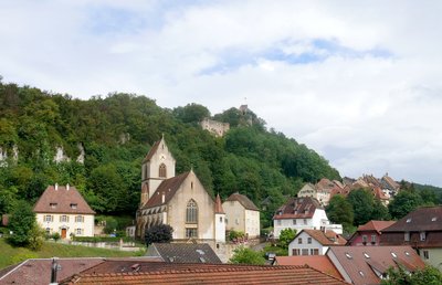
Le site du château de Ferrette avec l’église Saint-Bernard de Menthon - Amis saint Colomban HistoricalThe castle of Ferrette
In 1105, the two heirs of the Count of Montbéliard decided to share their possessions. Frédéric appropriated the Alsatian lands and became the 1st Count of Ferrette. He had his castle built as an eagle's nest on a hill overlooking the Jura valleys and the Sundgau valleys.
Very quickly, the Counts of Ferrette carved out an estate that would make them one of the most powerful houses in Alsace. It is from this period of more than two centuries that the county is practically a sovereign state.
As early as 1208, Frederic II endowed the town with a municipal regime and surrounded it with a wall in 1233. In 1271, Ferrette is mentioned for the first time as a town.
The lust for this stronghold was often the cause of destruction and invasions in the centuries that followed. Through alliances and marriages the Counts of Ferrette made this County prosper until the Prince of Monaco, who by marriage is still Count Ferrette today.
Before arriving at the church, a set of panels, hung on the wall in the passage of the Halle au Blé, present the history of the Counts of Ferrette.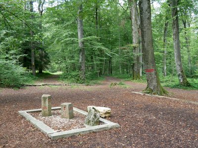
Les trois bornes à Réchésy - Amis saint Colomban HistoricalThe Three Powers Terminals at Réchésy
Bei einem Spaziergang durch den Wald werden Sie eine ungewöhnliche Entdeckung machen, die die Geschichte dieser Region geprägt hat. Als Grenzmarkierung, die 1871 gesetzt wurde, materialisiert sie die Überschreitung der Grenzen Deutschlands, seit dem Sieg 1871, der Schweiz und Frankreichs ohne Elsass.
Die Informationstafel auf der Website fasst dieses Ereignis zusammen.
Es ist der höchste der 3 Meilensteine, die es an diesem Ort gibt. Es wurde am 28. September 1871 (die aktuelle Version wurde 18901 installiert) eingerichtet, um den Treffpunkt der deutschen, französischen und schweizerischen Grenze zu markieren (die Anordnung dieser alten Grenzziehung wurde mit roter Farbe darüber aufgetragen, wie auf dem Foto links zu sehen ist). In den folgenden Jahren wurde dieser Ort zu einem echten patriotischen Wallfahrtsort.
Daneben befindet sich ein kleinerer Grenzstein mit einem "F" (für "Frankreich") und einem "D" (für "Deutschland"), Registernummer 4056, der zu einem Satz von 4.056 Grenzsteinen gehört, die zur Abgrenzung der Grenze von Redange (Mosel) zur Schweiz gesetzt wurden, um die Grenze zwischen Frankreich und Deutschland als Folge des Deutsch-Französischen Krieges von 1870 zu definieren (derzeit definiert dieser Grenzstein die Grenze zwischen dem Gebiet von Belfort und dem Oberrhein). Damit war der "Drei-Mächte-Posten" sozusagen der 4.057. deutsch-französische Grenzstein.
Der 3., kleinste und am meisten degradierte ist schließlich nur die Basis eines Grenzsteins aus der Zeit der Habsburger, als das Elsass Teil des Heiligen Römisch-Germanischen Reiches war, bis zu den Westfälischen Verträgen von 1648.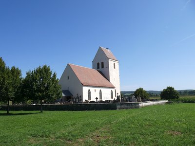
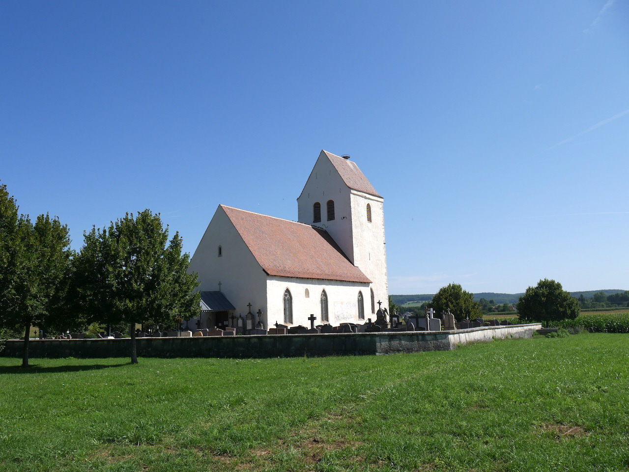
L’église Saint-Martin-des-Champs à Oltingue - Amis saint Colomban TouristSaint-Martin-des-Champs Church, in Oltingue
Located on the Via Colombani
Before your arrival in Oltingue this charming church, surrounded by a cemetery will tell you its story. It was the parish church of three villages before the construction of a new church in the centre of Oltingue.
As early as the 7th century a family of notables had erected a small cemetery chapel on the site of a former Gallo-Roman rural settlement. Classified today as a historical monument, archaeological excavations, carried out in 1989, made it possible to distinguish four phases of development from the 12th to the 13th century. The present church was built at the end of the 13th century and was remodelled in 1868 (neo-Gothic windows and doors). Excavations uncovered various burials still visible today: a monolithic sarcophagus (7th, 8th centuries), a masonry tomb from the 8th century: it contains a skeleton whose raised feet rested on the bones of five individuals.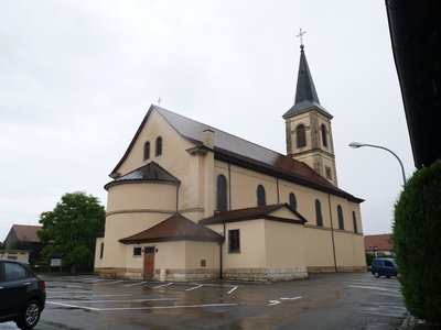
L’église Saint-Martin au centre d’Oltingue - Amis saint Colomban TouristSt. Martin's church in the centre of Oltingue
Located on the Via Colombani
The decision to build a new religious building dates back to August 11, 1824; the local population had doubled since the Thirty Years' War. The mother church of St. Martin was no longer sufficient, moreover it was too far away (1 kilometre), and was a source of inconvenience in case of bad weather (especially in winter) and an obstacle to the sacrosanct principle of the church in the middle of the village.
More information on the website of the commune .
Look at the Monuments aux Morts of the commune in front of the church. The statue represents Saint Martin sharing his coat with a poor man. All the symbolism of the sharing proposed in homage to the dead of the three world wars.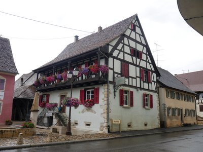
Le Musée Paysan proche de l’église Saint-Martin - Amis saint Colomban TouristThe Peasant Museum in Oltingue
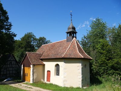
La chapelle Saint-Brice dans la forêt d’Oltingue - Amis saint Colomban TouristSaint-Brice Chapel in Oltingue
Located on the Via Colombani
After having left the town of Oltingue you continue your walk in the forest, the Saint-Brice chapel offers you all its country charm. Saint Brice, successor of Saint Martin at the head of the monastery of Tours, is often associated with the cult of the apostle of Gaul.
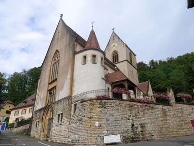
L’église Saint-Pierre et Saint-Paul à Hagenthal-le-Bas - Amis saint Colomban TouristThe Church of St. Peter and St. Paul in Hagenthal-le-Bas
In 1195, under the pontificate of Pope Celestine III, the parish of Hagenthal became part of the bishopric of Basel. In 1858, the ringing of the bells was stopped for fear of the tower collapsing. In l859, Boch de Ferrette drew up a project for the construction of a bell tower next to the choir. It was probably not carried out.
A few years later, as the building was in very poor condition, the architect Nicolas Risler-Tournier, a native of Mulhouse, was commissioned to draw up the plans for a new construction. The foundation stone was laid on July 7, 1868: in a neo-Romanesque style, the church is composed of a rectangular nave, a porch tower, a three-sided choir and a sacristy against the choir. The construction was definitively completed in 1872. But the roof was too heavy for the weak walls. In 1899, metal tie rods were installed.
Description
In Ferrette, go around the church on the right, access road to the castle, pass at the foot of the wall, straight down, pass under the porch of the house overlooking the road, rue Saint-Bernard.
- Left rue du Château, left rue du Colonel Robelin, before the bend to the right take the dirt road on the left first road on the right after the house, straight ahead, stay on the main road, signposted Chemin de Compostelle
- Turn left at the second crossroads of 4 roads, stay on the main road.
- At the exit of the wood turn right at the crossroads right at the crow's-foot left, stay on your left, left in front of the church tarred road, left at the fork after parking cemetery, in Oltingue, Kirchweg, continue rue de l'Eglise, left rue de L'Ill take the small bridge right cross the place Saint-Martin, along the church, left rue Principale
- Second street on the right rue de Leymen, straight ahead on tarmac road at the crossroads
- At the entrance to the woods leave the D 981, take a dirt road on the left, signposted Chemin de Compostelle, on the left stay on the main road, on the right at the Saint-Brice chapel go up to the main road on the left in the woods.
- Turn left at the crossroads with D 9B, first road on the right, follow the signs for Chemin de Compostelle, go straight ahead on the forest road.
- At the entrance of Hagenthal-le-Haut, chemin de Heiligenbrunn, turn left at the Sainte-Catherine chapel, then right on rue Principale at the second crossroads, turn right on route de Ferrette, rue de Bettlach, on your right the Saint-Pierre and Saint-Paul church of Hagenthal-le-Bas.
- Departure : Saint-Bernard de Menthon Church, 1 rue Zuber, 68 480 Ferrette
- Arrival : Church of St. Peter and St. Paul, 1 rue de l’Église, 68 220 Hagenthal-le-Bas
- Towns crossed : Grand Est
Altimetric profile
Report a problem or an error
If you have found an error on this page or if you have noticed any problems during your hike, please report them to us here: