22. Bivio to Vicosoprano
12 points of interest
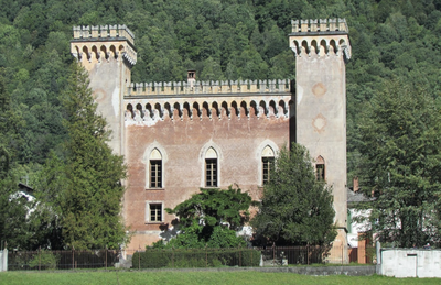
Fort Castelmur HistoricalCastelmur Castle
The five-storey square keep was built around 1300 probably on a Roman site called Murus and the site of an ancient fortress listed in a 988 document. This fief castle of the Castelmurs (Castello Muro) lost its strategic importance on the road to the Septimer when the Viamala opened in 1473 over the Splügen and St. Bernard Pass.
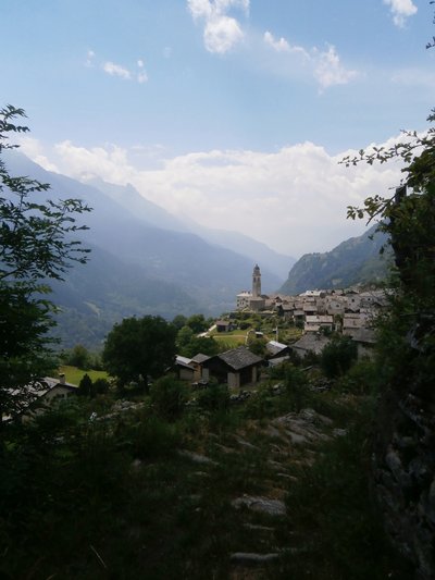
Village perché - Amis St Colomban PanoramicPerched village
First village perched on the Italian side of the Alps.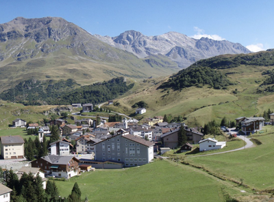
Bivio HistoricalBivio
Bivio means bidirectional because the village is at the crossroads of valleys that descend from two passes, the Septimer and the Julier. In history, the settlement of the village already mentioned in the 9th century is a function of the traffic towards these two passes. This place is also at the crossroads of different languages and cultures: the 200 or so inhabitants of Bivio speak three languages: Italian, Rhaeto-Romanic and German.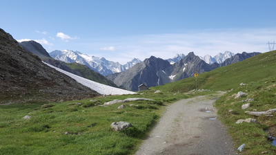
Col du Septimer PanoramicSeptimer Pass
At 2310m altitude, the Septimer Pass is the highest point of the entire Via Columbani across Europe. This pass has always been one of the most important transit routes due to its ease of crossing (low altitude, speed and accessibility). In Roman times it was crossed by a Roman road maintained and guarded in summer by a Roman camp excavated at 2340m. Later, the possessions and customs revenues on this axis of the Septimer, from Chur to Chiavenna, were the source of the power and wealth of the Bishop of Chur from 960 onwards. Traders and armies, kings and emperors, Otto the Great and Frederick Barbarossa, all crossed this pass, the most important transalpine transit route of the Early Middle Ages with the Great St. Bernard and the Brenner. From 1938 onwards, the Swiss army built fortifications at the Septimer to prohibit the crossing from Italy. This dam was abandoned in the 1990s. A plaque commemorating the Way of Saint Columban was erected in 2008 to mark the passage of Saint Columban at this location.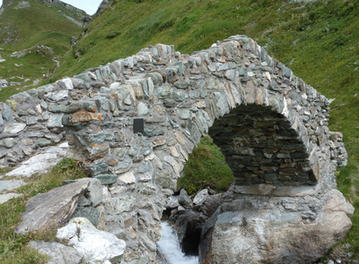
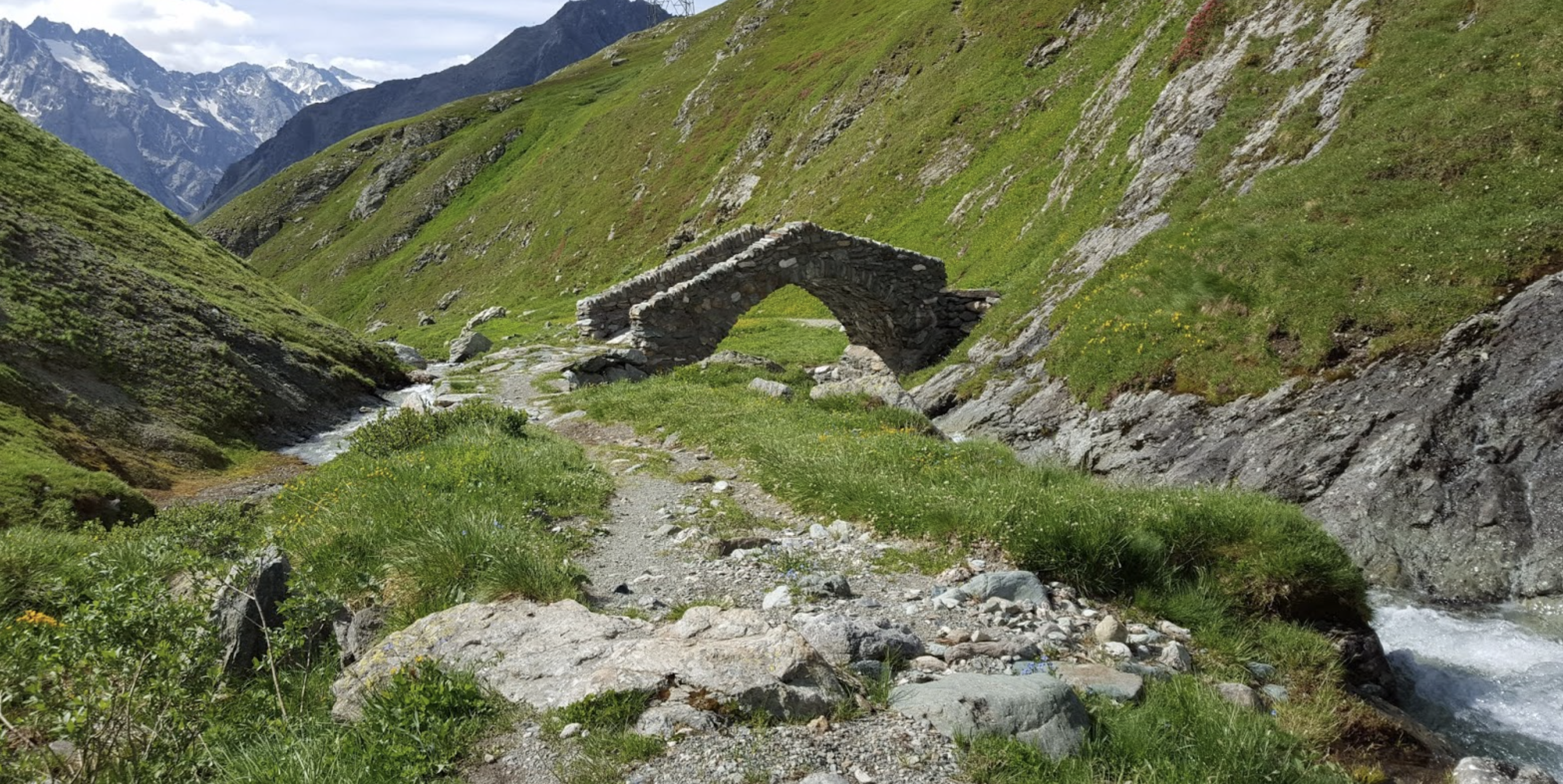
Voie romaine Septimer - Amis St Colomban HistoricalRoman road
Remains of a bridge and Roman road in the descent of the Col du Septimer.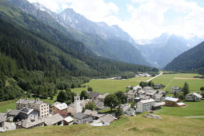
Casaccia HistoricalCasaccia
A small mountain village with characteristic chalets, Casaccia at 1450m was first mentioned in 1160. Casaccia was an important transit station until the 19th century due to its position at the junction of the Maloja and Septimer passes. The ruins of the medieval tower of Turraccia above the village are a reminder of this function. The old hospice was located near the ruins of the ancient San Gaudenzio sanctuary on the road to the pass. It was mentioned in a document in 1336, but it is probably much older.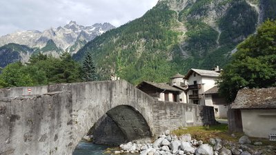
Vicosoprano HistoricalVicosoprano
Near the church of St. Cassian, a Roman altar of Mercury from the 2nd half of the 4th century has been found. Until 960 the inhabitants of Como were subordinate to the bishop of Chur. Vicosoprano was then the capital of the community of the Bergell Valley, a transit centre and residence of important families (Castelmur and Prevost). The bailiff of the bishop of Chur dispensed justice in the Senwelenturm, the only medieval round tower in Graubünden, which dates from the 13th century and was first mentioned in 1314.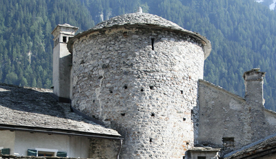
Senvelenturm HistoricalSenvelen Tower
The only round tower in Graubünden, it dates from the 13th century. The bailiff of the bishop of Chur rendered justice there.
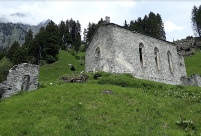
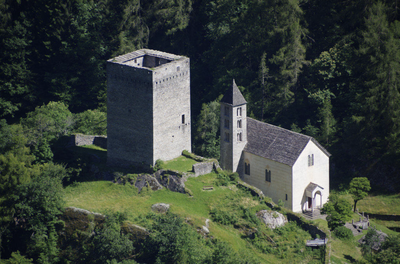
Église San Gaudenzio HistoricalChurch of San Gaudenzio
In the 4th century, Gaudentius Christianized the Bergell valley where he had found refuge to escape from the Arians. The church of San Gaudenzio is dedicated to him and was for a long time a place of pilgrimage. The ruined building today dates from 1518, but the presence of a chapel is mentioned in 831 in an imperial register of Charlemagne.
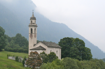
Église San Giorgio CulturalSaint George's Church
The church of San Giorgio was rebuilt in 1694. The interior is decorated with a stained glass window in the choir's lunette, the work of the famous regional artist Augusto Giacometti. In the nearby cemetery are the graves of the family of artists of two generations: Giovanni, Augusto and Alberto Giacometti.
Musée Giacometti CulturalMuseum Ciäsa Granda
The museum, housed in an imposing 16th century house, is dedicated to artists from a family from Borgonovo, a small mountain village, and of world renown: Giovanni Giacometti (1868-1933), his brother Augusto (1877-1947) and Alberto (1901-1966) son of Giovanni.
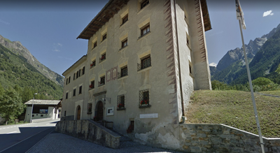
Palais Castelmur HistoricalCastelmur Palace
In Coltura, the northern part of the Castelmur Palace was built in 1723, the southern part in 1850-55 by Baron Giovanni Castelmur. The Moorish Gothic style and the towers decorated with battlements give the building the appearance of a castle, the beautiful gardens complete this impression. Today the Palace houses the Historical Archives of the Valley.
Description
From the church, join the main road to cross the village (1769m). At the exit, take the first asphalt track that goes up to the right (signposting):
- The road climbs gradually up this slope to isolated farms (Tua 1905m) and then leads to an open valley that naturally leads to the Col de Septimer. Continue on the track that approaches the stream (Eva dal Sett) and crosses several alpine hamlets: Motala (1909m), Prevostigm (1914m), Fumia (1936m) and Cadval (1993m).
- After crossing the torrent, the track goes up the other side over small gorges to pass a lock formed by an intermediate ridge: the Motta (2165m). At the end, the valley opens again and gives a glimpse of the Septimer Pass. Before crossing the torrent again, it is possible to leave the track and take a path to the left that arrives at the pass in a more direct way.
- The pass (2310m) is indicated by a topographical sign but also, a little further on the right, by a plaque in homage to Saint Colomban sealed on a rock. The Septimer marks the watershed between the North Sea via the Rhine and the Adriatic Sea via the Po. The descent begins at the top of the right bank of the stream. At the signpost N°64 (2280m), turn left into the path that joins and crosses the stream (Aua da Sett). The path follows the stream, crosses it several times and goes down more and more steeply in bends until it opens into the Maira valley.
- Go down through the left side of the stream, pass a last lock in rocks before accessing the mountain pastures that lead to Casaccia. At the end of the path, turn right onto the track that goes towards the road.
- After the cemetery, take the marked track on the right. At first, parallel to the road, it deviates from it to follow the Maira River and a dam lake and then remains level (1350m) on the right side of the river which is losing altitude much faster. The trail reaches the village of Rotticio (1267m).
- Go down towards Vicosoprano by cutting the road's bends, taking it when it is straight and taking a path to the right after the bridge over the river. The visible church is on the left at the central crossroads of the village.
- Departure : Church, 7457 Bivio
- Arrival : San Trinita church, Muntegn, 7602 Vicosoprano
- Towns crossed : Graubünden
Altimetric profile
Report a problem or an error
If you have found an error on this page or if you have noticed any problems during your hike, please report them to us here: