9. Koblenz to Boppard
3 points of interest
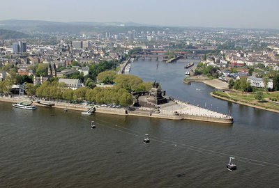
Le Deutsche Eck - Wikimedia commons Holger Weinhandt HistoricalDeutsche Eck in Koblenz
The Deutsche Eck (German Corner) is the name of a promontory in Koblenz, where the Moselle joins the Rhine. In 1897, nine years after the death of German Emperor Wilhelm I, he was honoured with a monument signed by Bruno Schmitz topped by a giant equestrian statue of the late emperor. On the pedestal was engraved a quotation from the poet Max von Schenkendorf from Koblenz: "Nimmer wird das Reich zerstöret,/ Wenn ihr einig seid und treu! "("Never will the Empire be destroyed, as long as you are united and loyal").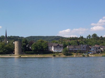
Remparts à Rhens avec la Tour des sorcières - http://www.rhens-fuehrungen.de HistoricalWitch Tower in Rhens
Rhenser Scharfer Turm (Witches' Tower) The Scharfer Turm, built from 1396 onwards, is located directly on the Rhine and has a total of four floors, including the tower platform. It is the most important part of the city wall. It was first used as a scouting and customs tower and then as a prison (1629-1648). In 1645, ten "witches and sorcerers" were beheaded there after being tortured by the executioner.
Further information: Romantischer Rhein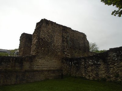
Castrum romain de Boppard - amis de saint colomban HistoricalRoman Quarter Boppard
Wherever you go in Boppard, you will be reminded of its Roman history. Boppard was one of the most important Roman settlements on the Middle Rhine. As a result of Julius Ceasar’s conquests, this region was also under Roman rule. Boppard began as a Celtic settlement with the name “BAUDOBRIGA. The Romans made their first settlement at the entrance to Mühltal, to the west of the town. In the middle of the 4th century, they built a fortification which they named BODOBRICA which later became BOPPARD, the present-day name.
The fort was built near the Rhine and impressed by its size. It was 308 × 154 metres and formed a rectangle of 4,7 hectare. The walls were 3 metres thick to the land side and 2,5 metres thick to the Rhine side. With a height of 9 metres and 20 horse-shoe shaped towers to the land side, each 27 metres apart, the wall made a very powerful fortification.
When times became too troublesome for the Romans, they left the Rhine and the fort became the core of the present-day town. Today Boppard is a lively, modern town but the Roman roots can still be seen. The remains of the Roman Fort surround the town centre and are the best example of a Roman fort in Germany.
You will find the Roman Fort in the Angertstrasse / on corner of Kirchgasse in the town centre of Boppard. The ruins are open-air and you can visits at all times free of charge.
More information : Boppard Tourismus
Description
- Left in Rheinlache (Rhine Port), Mozartstrasse, at the roundabout second street on the right Schillerstrasse
- Third street on the left Schubertstrasse, right in front of the Rhine, pass under the two bridges, stay on the Rhine bank until you reach Rhens,
- In Rhens take the second street on the right under the Langstrasse railway, cross the B 9 Am Viehtor, stay on Im Zillgen to leave Rhens.
- After leaving Rhens continue on Langenackerweg, stay on the main road, then Krokenhof continue straight ahead at Siedlung Schauern, then after 450 m, take the path on the left and follow the forest path for 700 m, turn left after 200 m, stay on the left for 350 m, turn right and after 400 m turn left.
- Then turn to the right and follow the path up to "Vierseenblick" to enjoy the panorama over the Rhine valley. Go down past the "Gedeoneck", then take the path which follows the chairlift.
- Arriving in Mülhtal turn left under the railway, right B 9 left Kreuzweg follow the Rhine to the right Rheinallee, after Karmeliterplatz third street on the right Kronengasse, you arrive at the church of St. Severin.
- Departure : Basilica of St. Castor, Kastorhof 4, 56068 Kobenz
- Arrival : Basilika St.Severus,Rheinallee 44, 56154-Boppard
- Towns crossed : Rheinland-Pfalz
Altimetric profile
Report a problem or an error
If you have found an error on this page or if you have noticed any problems during your hike, please report them to us here: