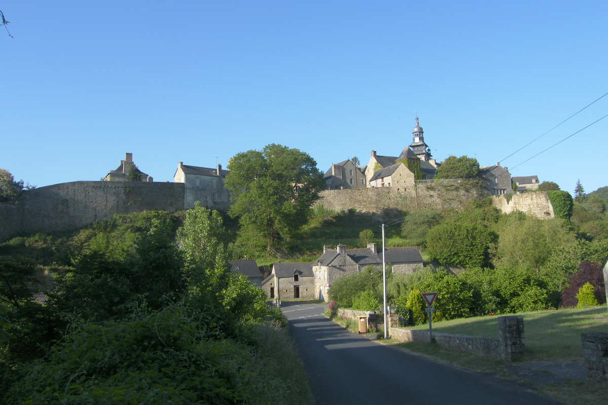
8. from Moncontour to St Brieuc
From the foothills of the Méné with their hilly landscape to the bay of St Brieuc with its very steep valleys, from the small rural villages to the urban agglomeration, from the castles, vestiges of the canvas industry before the revolution to the peri-urban industrial zones, the landscapes and atmospheres will be very varied during this stage.
3 points of interest
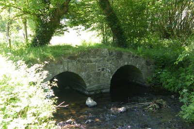
Pont de Chéra - Amis Bretons de Colomban TouristThe bridge of Chéra
This stone bridge spanning the Urn consists of two arches supported by a central pier and abutments on each bank. This type of architecture is typical of Gallo-Roman constructions.
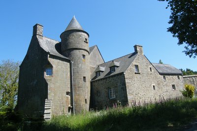
Manoir du Gué Lambert - Amis Bretons de Colomban HistoricalManoir du Gué Lambert
This manor house was declared in 1513 by Jean Jamet. It will be a chaplaincy until the Revolution. From 1580, it is the property of the Auffray family, some members of which will be members of the States, the king's musketeer, count...
Manor house of the Xvème composed of a cylindrical tower for the staircase. A trumpet-cut section had a surveillance opening on the indented corner, which is currently blocked. A bread oven remains preserved on the short side. The courtyard façade opens with a circular door.
To find out more...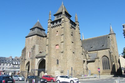
Cathédrale de St Brieuc - Amis Bretons de Colomban CulturalSt Etienne of St Brieuc Cathedral
St Brieuc Cathedral is a stage in the historic Tro Breiz (St Brieuc is one of the seven founding saints of Brittany).
It is a Gothic building built on marshland between the 13th and 17th centuries. It preserves relics of St Brieuc from the 6th century. It was burnt down in 1353. Rebuilt almost entirely, it was damaged again in 1394 during the siege led by Olivier de Clisson.
The two towers are fortified and one even has hourds. The spire of the Tour Marie, built in the 15th century, was destroyed by lightning in 1852.
To know more about it...
Description
Starting from the church square, go to the left of the church by the rue du Temple, then the rue des Dames and go down the stairs that extend it. Then turn left on rue de La Herse and, at its end, turn left on rue de la Vallée, then right on rue de La Vigne. Go up this one to the washhouse on your left.
- Take at the end of this one, the footpath which goes up on the road D1, cross it to continue on the path opposite, which then goes on the left. Follow him to the pumping station and join the path. At the crossroads, take the road on the left (yellow/red markings). At the hamlet of Chêne Loyo, turn right on the road before the farm buildings. Follow this path to the hamlet of Les Alleux.
- In the hamlet, turn right, and continue to the water reservoir of the mill of the Ville Norme, turn left to go around the pond, then right on the access road to the mill. At the crossroads turn left to reach Pallan. In this hamlet, take the road to the right before the transformer, then, at the fork, the path that goes up to the left.
- At the exit of the forest, bypass the pumping station and turn left on the road. At the exit of the car park, cross the car park, then the road and continue on the waymarked path towards St Carrec? Follow the edge between the field and the forest to reach the path that goes to the right. When the path disappears, go along the cultivated field by the right, and at the end of the field recuperate the path. Turn right in the direction of Le Fébillet balisage petite randonnée). At the end of the road, turn right onto the access road to the hamlet. Turn right at the hamlet of Cariza, and left at the top of the hill.
- Rejoin the farm of La Tournée, go along it and, before the last building, turn left on the road (yellow/red markings). At the next crossroads, turn right, then left in the direction of Bas Plessis. In this hamlet turn left (dead end). In the valley, turn left on the path under the trees. When he goes up, follow him back up to the field and reach the crossroads of Le Chauchix. Turn right and at the bottom of the hill, turn right onto the farm road (white/red markings).
- At the top of the hill, turn to the left at the fork near the farm building and join the hamlet of Veau Bonnet. Turn to the right, then to the right and finally to the left towards Aunay Noël. At the fork, turn left and continue straight ahead to the D25. Turn left, rue de la Creusée, and reach the church square.
- Passing the church, take on the right the rue des sabotiers, then immediately on the right the rue de la Croix Botrel. Before the industrial building, turn left into the rue de la Chênaie and then turn right onto the Thuyas dead-end road. At the edge of the forest, in front of the entrance to the Château du Plessis, take the path on the right. On arriving on the road, turn left and left again towards the City of Gloves. Go through the hamlet and at the crossroads, turn right, then left towards Bréchet.
- Before arriving at this hamlet, take on the right, the path which goes along the brook under the trees. When it joins the access road to Garais, turn left and continue straight on towards Pommier Agan. Go through this hamlet and turn left at the second crossroads. Continue straight ahead on the chemi at the next crossroads and join the rue Joseph Hervé. Turn left and go to the church square.
- Passed this one, continue on the rue du centre, and, at the roundabout after the cemetery, take on the right the rue du Bois. Continue on the path through the woods. At the crossroads with the road, continue straight on the path to the Magenta washhouse. Cross the D27 and take the direction of the Chéra bridge. At the junction with the road, turn right onto the D27, turn left and follow it to the next crossroads. Then turn left onto rue de Plédran. Follow it to the crossroads with the D10. Turn left, then turn right on rue du Bourgneuf.
- Cross the bridge on the four-lane road D222, and turn left to go along it. Follow this road to cross the bridge over the D700 and at the next crossroads turn right, rue du Guerneau. At the hamlet of Gué Renaud, take the path on the right just after the bus stop sign. Follow him to the manor of Gué Lambert. Pass to the left of the roundabout, turn right and join the roundabout.
- Pass under the four-lane bridge and turn left on the bicycle path that runs along the departmental road. At the end of this track, turn left on Théodore Botrel street, then, after the brook, take the track on the right. When you reach a clearing with a horse riding arena, take the path on the left, go up to the car park, follow it to the right and enter the exhibition grounds on the right. Cross this one, and pass the barriers, take on the right the chemin du Petit Pré in front of the horse club. Pass the brook, turn right onto the bike path. Cross the rue de Trégueux and take opposite the paths of the Parc de la Vallée du Gouedic.
- Arrived in view of the railway viaduct, turn left on the Vendel hill (direction of the station on red sign). Turn right on Boulevard Clémenceau. At the roundabout, turn left onto Rue du 71ème Régiment d'Infanterie. At the traffic lights, turn right into rue des Lycéens Martyrs (towards the historic centre), then into rue Poulain Corbion to reach the cathedral.
- Departure : St Mathurin Church - Dr Sagory Street - 22510 - Moncontour
- Arrival : St Etienne Cathedral - Rue de La Préfecture - 22000 - St Brieuc
- Towns crossed : Bretagne
Altimetric profile
Transport
Public transport in Brittany is grouped on Breizhgo and Mobibreizh.
Report a problem or an error
If you have found an error on this page or if you have noticed any problems during your hike, please report them to us here: