10. From Hillion to Lamballe
First part of the stage along the "sentier des douaniers" (customs officers' path) passing through the points of Grouin and Guettes to reach the cove of Morieux. Then up the steep and wild valley of the Gouessant and its water reservoirs, crossed by the viaducts of the old railway line. Finally, the urbanisation will be felt more and more before reaching Lamballe.
5 points of interest
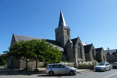
Eglise d'Hillion - Amis Bretons de Colomban CulturalChurch of Hillion
Built on the foundations of a Romanesque building, the church of Hillion, dedicated to St John the Baptist, dates mainly from the 14th and 15th centuries. The granite stoup dates from the 14th century.
It was included in the supplementary inventory of Historical Monuments in 1970.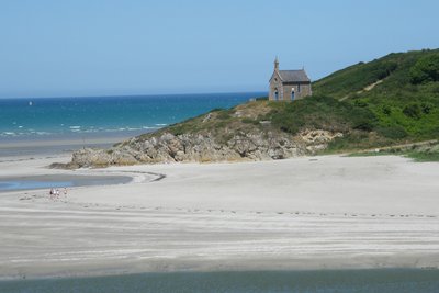
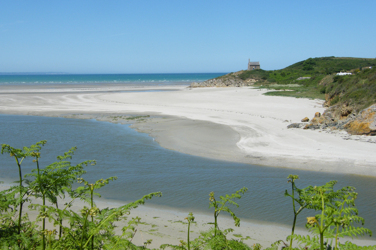
Chapelle St Yves - Amis Bretons de Colomban CulturalThe chapel of St Yves and St Mathurin des Marais
This 17th century chapel replaces an older building dedicated to St Yves.
The canonisation trial of St Yves relates that Guillaume de Tournemine, son of the lord of Hunaudaye, was about to be swallowed up by the tide after venturing too far on the strikes. He then devoted himself to St Yves and was saved. In recognition of this, he built the chapel of Saint Yves des Marais around 1330.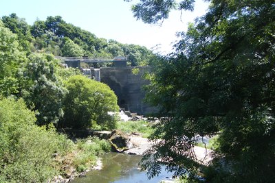
Barrage de Pont-Rolland - Amis Bretons de Colomban TouristPont Rolland dam
The Pont-Rolland hydroelectric dam is fed by the Gouessant river. It is completed, about 100 metres downstream, by a power station. The EDF concession ended in 2010 and electricity production stopped in 2013. The dam is state-owned.
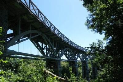
Viaduc de Ponts-Neufs - Amis Bretons de Colomban TouristThe Ponts-Neufs viaduct
Ce viaduc en courbe a été construit à partir de 1913 par Louis Harel de La Noë pour les Chemins de Fer des Côtes-du-Nord. Il a été restauré en 2014 par le Conseil Général des Côtes d’Armor.
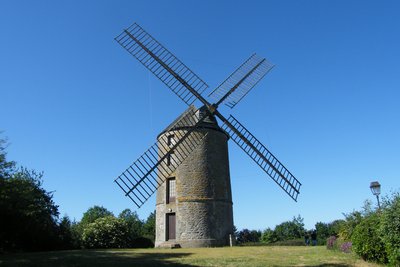
Moulin de St Lazarre - Amis Bretons de Colomban PanoramicThe St Lazarre mill
The windmill of St Lazarre was built between 1788 and 1829 at the top of Mount Boët by the Duke of Penthièvre who owned it until 1789.
Its 22m wings were added in 1974 and restored in 2012. They were designed to receive sails but were never equipped with them.
The last miller ceased his activity in 1901. Bought by the municipality in 1972, it is currently occupied by an association. It was listed on the Supplementary Inventory of Historical Monuments in 1977.
Description
Leave the church square by going down the rue de l'Hôtellerie and join the frève d'Hillion. Then turn right, pass between the houses and continue along the coastal path (red/white markings).
- At the junction with the road to Saint Guimont, turn left and, just before the fountain, take the path to the right and join the Pointe du Grouin, then the Pointe des Guettes and, still on the coastal path, join the beach of Lermot. Pass the car park and continue on the marked path towards the Bon Abri beach.
- At the junction with the road at the campsite, turn to the left on the road and again to the left at the crossroads. After the car park, turn to the right on the red/white marked path towards the Pont Rolland.
- Follow the signposted path to Granville beach, cross the access roads to continue on the path and reach the mouth of the Gouessant. Continue on the left bank of the Gouessant to join the D34 at the place called "Pré Colas".
- Turn left onto the road and cross the bridge in front of the dam on the Gouessant. On the hill, turn right onto the path marked out in yellow/red towards the Ponts-Neufs. At the junction with the Route du Fros, turn right and go down towards the Ponts-Neufs. At the crossroads with the D786, continue straight ahead on the rue de l'étang to follow the new reservoir on the right bank.
- At the exit of the village, take the yellow/red marked path on the right towards Coetmieux. Follow this path to the end of the pond and cross the river by the footbridge. At the end of the footbridge, take the path on your left and join Coetmieux by the Chemin du Val aux Moines. At the crossroads with the rue des Ponts Neufs, turn left, then go straight on by the rue de la Fontaine. After the first two crossroads, continue along this street and turn right at the fork and join the place called La Lande Orhan.
- In the hamlet, turn left onto rue du Bas de la Lande until you reach rue de La Lande Orhan. Turn right then left onto rue du Marchix. At its end, turn right onto rue du Bignon, then left onto rue de Belleville (signposted Tro Breiz). At the entrance to the hamlet of Belleville, turn right onto the path following the yellow/red markings to reach the rue du Frêche. Follow this street up to the crossroads with rue Morvan. Then continue straight ahead on the Venelle du Roi Morvan. At the exit of the hamlet take the path on your right (yellow/red markings). Follow this path and then turn left before going under the HV power line,
- Turn right at the crossroads with the access road to the hamlet of La Ville au Roi and continue in the direction of Lamballe passing over the four-lane road. In the curve, turn left in the direction of Belle-Vue. Pass this hamlet and at the next crossroads, take the path that leaves on the left. At the hamlet of Made, turn right just after the house, pass under the railway and take the path on the left which runs along it. When it joins the four-lane road, cross it by the subway and join the ZA de Beausoleil.
- At the exit of the tunnel, turn right on the rue de Beausoleil, then left on the impasse du Beausoleil. At the end of this road, continue straight ahead on the path, to the left of the silos, and reach the impasse du Champ Clos Maroue. Turn left on this road, then, in the bend, continue straight ahead on the path. At the top of the hill, turn left to go past the St Lazarre mill. Then turn right on the chemin de la Garenne. Continue on this road, passing under the railway line, continue on rue St Lazarre, rue du Grand Boulevard and rue St Jean to reach the church of St Jean.
- Departure : Church Square - 22120 - Hillion
- Arrival : Église St Jean – Parvis St Jean - 22400 - Lamballe
- Towns crossed : Bretagne
Altimetric profile
Recommandations
Transport
Public transport in Brittany is grouped on Breizhgo and Mobibreizh.
Access and parking
Accessibility
- Emergency number :
- 114
Report a problem or an error
If you have found an error on this page or if you have noticed any problems during your hike, please report them to us here: