12. from Bourseul to Taden
The Poudouvre is a traditional country located between the river Arguenon and La Rance. We are also in the country of the Coriosolites, Gallic tribes whose capitals were Aleth (originally St Malo) and Corseul. The Gallo-Roman ruins in Corseul, those of the temple of Mars or the Gallo-Roman way from Corseul to Taden are the remains of these tribes.
6 points of interest
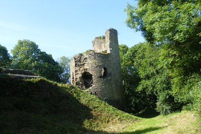
Château de Montafilan - Amis Bretons de Colomban HistoricalMontafilan Castle
Situated on a promontory surrounded by two deep, marshy valleys, this fortress was built in the 12th century. It included six towers and two chapels. One of them was dedicated to St Anne . In the other one, a Gallo-Roman altar was found which has been preserved in the Dinan museum since the XIXth century. The last owner, Françoise de Dinan, was the tutor of Anne of Brittany. It was classified Historical Monument in 1926.
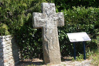
Croix de Montafilan - Amis Bretons de Colomban CulturalMontafilan Cross
This Merovingian cross in granite measures 2.30m above ground. A christ probably hammered at the Revolution remains visible in low light. This monument is probably a prehistoric monolith Christianized in the Merovingian period.
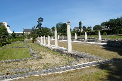
Vestiges de Monterfil - Amis Bretons de Colomban HistoricalThe Gallo-Roman remains of Monterfil
The remains of this commercial district were excavated between 1986 and 1998. It has a lane lined on both sides with Tuscan-style colonnaded porticoes, and the bases of the warehouses and residential houses are still visible. The complex was declared a Historical Monument in 1995. Objects found during excavations are exhibited at the Heritage Interpretation Centre.
To find out more...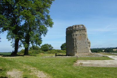
La Cella - Amis Bretons de Colomban HistoricalMars Temple
This Roman temple of Gallic tradition was built in the middle of the 1st century AD. It was used until the IIIth century. It "s the highest Gallo-Roman vestige in Brittany. The dimensions of the temple make it one of the largest sanctuaries in Gaul. It was classified in the MH in 1840.
The most visible element is the cella where the statue of the divinity was originally located. It is octagonal on the outside and hexagonal on the inside. In front was a courtyard surrounded by galleries on three sides.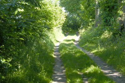
La voie romaine - Amis Bretons de Colomban HistoricalThe path of the Etra
The path of the Etra (or Lestra) is an ancient Roman road linking Corseul to Avranches via Taden. The goods arriving by sea were unloaded in Taden and then take this route. During repair work there were coins, axes and scales visible in the windows of the town hall.
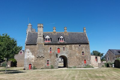
Manoir de la Grand’Cour - Amis Bretons de Colomban CulturalTaden
St Peter's church dates from the 14th century and was rebuilt in the 19th century. In 2003, rehabilitation work revealed the presence of 14th century mural paintings.
The manor of the Grand'Cour is a seigniorial residence of porch dwelling type from the late Middle Ages. It was classified as a MH in 1993.
Description
Leave the centre of Bourseul by the rue de Chappedelaine (D68). Follow the departmental road to the sports ground. Turn right at the crossroads just before it, and at the next crossroads turn left towards La Guiternais.
- Cross the hamlet and, in the valley, turn to the right on the track. At the next crossroads, turn to the right and join the hamlet of La Roche (signposted Tro Breiz). Turn to the left at the entrance of the hamlet, then to the right at the next crossroads. Then take the path on your left which leads to the grove. Follow the grove, leaving it on your right and join the D19.
- Cross the road in the direction of Ste Eugénie. In the hamlet of Ville du Bos, continue on the road to the right and, after the bend to the left, continue straight ahead until you reach the hamlet of Ste Eugénie. In front of the chapel of this hamlet, turn right and, a hundred meters after leaving the hamlet, take the road on your left. Pass the hamlet of La Saudrais and continue to the crossroads. Then turn left. (signposted Tro Breiz).
- Follow this road up to the crossroads of Rault City. Turn to the right on the road lined with trees. Follow this road up to the hamlet of Hôtel Ravard. Then turn to the left, the dead-end road towards the castle of Montafilan... At the entrance to the hamlet, turn right on the path that goes down to the ruins of the castle. After the ruins, continue straight ahead on the track and join the D68. Turn right on the D68.
- Halfway up, turn to the right on the road and follow it up to reach the road parallel to the road D794. At the crossroads with this road, turn to the right in the direction of Fresnais, then, at the entrance of the hamlet, turn to the left in the direction of the water tower. Pass to the right of the water tower by the rue de la Métrie and turn left on the rue de Montafilan to join the rue de l'Arguenon. Turn right on this street. Go past the church and the Gallo-Roman remains and, at the exit of the town, turn right into the driveway towards the hamlet of Trégouet.
- In front of the barrier of Trégouet, turn to the left on the track and follow it along the river. Turn to the left on the road, and before the crossroads with the departmental road, turn to the right on the track. Near the ruins of the temple of Mars, continue on the road until the crossroads with the departmental road. Cross it and head towards Vauhesry. Cross the hamlet and continue to the crossroads after the Marette. Turn right and go to the level crossing.
- Cross this crossing and take at once the track "des pâquerettes" on your right. Turn to the left at the first crossroads. Cross the road and continue on the track "chemin de l'Etra" (old Roman road). Follow it to its end (third crossroads) and then turn left onto the road. Turn right on the road after the Club Canin. At the end of the path, go over the embankment near the Avaugour nature reserve sign and a few metres further on you will find the forest path.
- Turn to the left on this alley. At the end of the forest alley, turn to the right on the track, then, at the crossroads, turn to the right on the road. Turn to the right on the first forest alley (with barrier). Follow it up to the crossroads with the road D2. Turn left on the departmental road, then at the crossroads, take the road on the right . Follow this road until you reach the electricity station. Then turn right, and continue left on the road opposite the entrance gate. Continue straight ahead until you reach the roundabout near the four-lane road.
- Pass under the road and follow the street "rue de Carheil" up to the water tower. Turn to the right on the track just after this one (signposted Tro Breiz). Cross the railroad at the crossing n°159 and turn to the right at the next crossroads. At the crossroads with the calvary drowned in the shrubs, turn left and join the town of Taden. Cross the roundabout at the entrance to the town and turn left into the rue de Montpertuis to reach the church.
- Departure : St Nicodème Church - Rue Chappedelaine - 22130 - Bourseul
- Arrival : St Peter's Church - Church Square - 22100 - Taden
- Towns crossed : Bretagne
Altimetric profile
Transport
Public transport in Brittany is grouped on Breizhgo and Mobibreizh.
Report a problem or an error
If you have found an error on this page or if you have noticed any problems during your hike, please report them to us here: