3. Chiavenna to Verceia: variant via Via Francisca
8 points of interest
Collegiata San Lorenzo CulturalCollegiate Church of San Lorenzo
Collegiate church of San Lorenzo of Romanesque origin, rebuilt after the fire of 1538, with the magnificent cloister of the cemetery and the isolated bell tower, the recently built Treasure Room is remarkable, where the famous and precious treasure is also displayed.
Pace (upper cover of an evangelist, 12th century Lombard-Renian art). To the left of the church is the baptistery where the Romanesque baptismal font, consisting of a monolith in soapstone with reliefs, is preserved (1156).Crotti TouristCrotti, regional originality
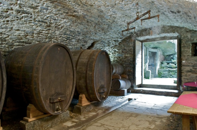
Interesting and particular to Chiavenna are the "crotti", the natural cavities due to the old landslides in which air currents (sisters) from the internal voids circulate: the temperature is never higher than 10 ° C, therefore ideal for the storage of wine, cheese and meat. At the mouth of these cavities, the Chiavennaschi have built small buildings for friends' meetings or used as typical places where you can taste the local specialities. Near the station, in a square with century-old plane trees, Pratomagno, there are the most characteristic eruptions. The famous Sagra dei Crotti takes place on the second Sunday in September.itinéraire TouristRoutes in Chiavenna
Paradise Park: an interesting botanical-archaeological itinerary. Potholes path of the giants, an area with glacial formations dug in the rock. It is also pleasant to walk around the city from the SS36 bridge over the Mera river, to observe the houses built overlooking the river, some of them are pastries or bars that also overlook via Dolzino, have small terraces that allow you to enjoy an aperitif while admiring the environment. Going through Dolzino, the main street, you are in front of the Palazzo Salis, now transformed into a B & B, ask the nice owner to be able to admire the beautiful ballroom in the rococo style. Via Dolzino offers elegant gates, remarkable palaces, beautiful windows and the stone of the pillory.
Torrente Boggio - Amis St Colomban PanoramicBoggia torrent
The Boggia torrent rises in the splendid Bodengo valley, rich in pastures, the last section is a deep furrow carved by the fury of the water: even our small bridge is the last of a long series destroyed by the impetuous fall.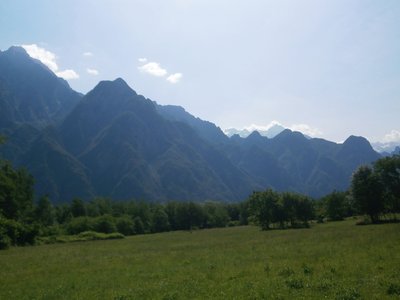
Amis St Colomban PanoramicCesura Plain
A stretch of grass called the Cesura, the result of work to reclaim the plain, begun but never completed by the leader Gian Giacomo Trivulzio, who at the end of the '400 was lord of the Chiavenna countryside.
Leonardo da Vinci was also involved in the development of the plain: he was commissioned to study a waterway from Chiavenna to Lario, then the lake at Lecco and the Adda at Trezzo, then the Martesana canal and finally the Lambro at Po. All that remains of this evocative and grandiose idea, which never got off the ground, is a delightful description of the Val Chiavenna, the clear result of an inspection he carried out.Chiavenna HistoricalChiavenna
In 16 AD, Chiavenna was a Roman station of some importance, as it was the starting point for the two routes to Rhetia, either via the Spluga Pass or via the Septimo or Maloja and Giulia. Long disputed between the bishops of Como and Chur, it became a free municipality and then passed under the Visconti and Sforza, in the Duchy of Milan. From 1512 to 1797, the Chiavenna countryside and Valtellina became the property of the Grisons. With Napoleon, they once again became the Lombards' in the Cisalpine Republic. When it fell, despite an attempt at re-annexion by the Grisons, it remained attached to Lombardy-Veneziatia, viceroy of the Habsburg Empire. At the end of the Risorgimento, all the territories of Valchiavenna and Valtellina constitute the province of Sondrio. From the Habsburg era came the new roads of Spluga and Stelvio, which intensified relations with Milan and the whole of Lombardy.Chapelle San Giovanni all’Archetto CulturalChapelle San Giovanni all'Archetto
Chapel in ruins preserving a beautiful fresco of the saint who gave it his name.
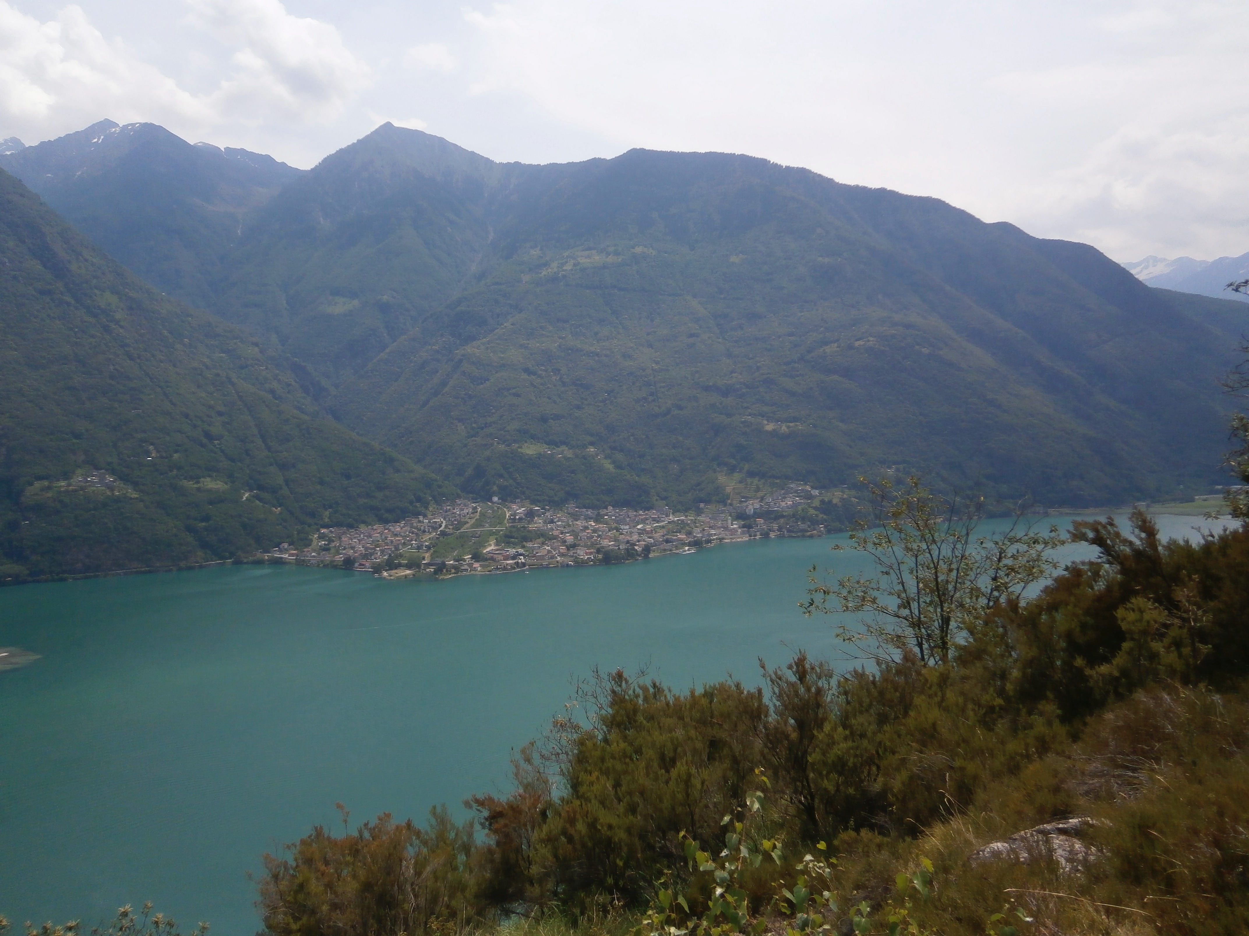
lac Mezzola - Amis St Colomban PanoramicLake of Mezzola
Panoramic view of Lake Mezzola at the point where the mountain river Mera flows into this lake, the first of a long series.
Description
On leaving the Collegiate Church of San Lorenzo in Piazza Don Pietro Bormetti, follow Via Don Luigi Guanella and turn left at the end onto Via delle Agostiniane, which you will follow until you reach Piazza Giovanni Bertacchi:
- Turn right into the square to reach Via Francesco e Giovanni Dolzino, a narrow shopping street. At the end of the fountain square, turn left into Via Carlo Pedretti until you reach a roundabout. Take the third street on the right (Via al Portone Vecchio) until the intersection with Via Roma. At the next crossroads turn right into Via Mario del Grasso until you reach the bridge over the Mera. Cross the river at this point and follow the other bank along a path that passes by sports facilities. Before the confluence with the Torrente Liro, the path turns right to join a track and a bicycle/pedestrian bridge to cross the torrent. Leave the cycle path on the left and turn left before the factories. Follow the Via Rebiatti until you reach a stop sign.
- Turn right onto Via Giavere and follow it until you reach the SP2 and then turn right onto Via Piatti until the end. The signposted path (yellow marker: Via Francesca) follows Via Don Primo Lucchinetti to the left until you reach the parish church. With the hydroelectric power station of San Francesco (1927) on the right, continue along its irrigation canals until you reach the road that climbs first to the church of Madonna delle Grazie, then to Albareda, cross it and take the road (then path) that, passing two small valleys, climbs to the municipality of Coloredo (330m). Go through Coloredo following the road to the Forcola Pass, then descend to cross the Crezza stream, pass the sports field and finally take the Via Roma which leads to the centre of Cordona (3.2 km).
- Do not follow the road to Pendoglia and the Bodengo valley, nor the one to Alpe Signame, but the path to the Boggia stream waterfall: pass under a wash house and then over a small hydroelectric power station. At the crossroads after the bridge and a kiosk (280m), do not go up to the right towards the Alpe and then the Torre di Signame, but to the left over the stream and then along a beautiful stretch of paved road, slightly uphill, until you reach the panoramic point known as the Montée (290m), and then start to descend towards the embankment of the river Mera, which can be reached in part by means of a staircase (2.2 km).
- Go towards the Caslet sanctuary (220m) under the imminent Dosso di Signame (Tower). Along the way are the remains of the chapel dedicated to Santa Orsola and the ruins of the ancient farmhouse of Cesura; the route ends at the gates of the hamlet of San Pietro, one of the many hamlets that form the municipality of Samolaco. Shortly after the ford of the Mengasca stream, you reach the Rovrina aedicule (220 m) where the Via Overìna begins on the right and climbs towards the centre of the hamlet (2.1 km).
- Leave the hamlet of San Pietro along the road to the cemetery, go down to Via Prona, then right onto Via Peremonte (220m), then turn left and continue straight on the path that passes between the huts above Nogaredo and the ford of the Bolgadregna torrent towards the junction called Piazza (270m). Here begins the flat road called Schenone that leads to the path of the Era stream. After the ford, turn right and climb along the Via Crucis until you reach the isolated church of Sant'Andrea. Continue along the dirt road towards Montenuovo, where the asphalt road climbs with many hairpin bends first to the church of Sant'Andrea, then to the Paiedo pasture. After the hamlet of Montenuovo, go down at the first bend in the road and take the path on the right marked in yellow (Via Francisca). At this point, continuing along the winding road, it is possible to reach Novate Mezzola for a stopover on the eastern shore of Lake Mezzola. Alternatively, you can go down the path towards the hamlet of Casenda. At this crossroads there are two possibilities:
A) No diversions to go directly to Verceia.
B) Round trip via the San Fedelino chapel. - For the shorter route, go down to the intersection, take the direction of Giavere, cross the village (bus stop) and continue towards the bridge over the Mera (1.5 km).
- Cross the bridge, go down to the left and take the N6 cycle path that connects Chiavenna to Verceia. This path leads to your destination along the left bank of the Mera.
- After the bridge over the Pericchio stream before Novate Mezzola, turn right onto the cycle path that follows the stream and then the Mera river to Verceia.
- Departure : Basilica of San Lorenzo, Piazza Don Pietro Bormetti 3, 23022 Chiavenna (Italy)
- Arrival : San Fedele Church, Via Nazionale, 1, 23020 Verceia
- Towns crossed : Lombardia
Altimetric profile
Transport
Report a problem or an error
If you have found an error on this page or if you have noticed any problems during your hike, please report them to us here: